South Pickenham
| South Pickenham | |
|---|---|
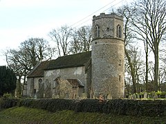
 All Saints CofE church | |
Location within Norfolk | |
| Area | 7.58 km2 (2.93 sq mi) |
| Population | 101 (2001 census) |
| • Density | 13/km2 (34/sq mi) |
| OS grid reference | TF8504 |
| Civil parish |
|
| District | |
| Shire county | |
| Region | |
| Country | England |
| Sovereign state | United Kingdom |
| Post town | Swaffham |
| Postcode district | PE37 |
| Dialling code | 01760 |
| Police | Norfolk |
| Fire | Norfolk |
| Ambulance | East of England |
| UK Parliament | |
South Pickenham is a small village and civil parish in the Breckland district of mid Norfolk, East Anglia, England. It has an area of 758 hectares (2.93 square miles) and it had a population of 101 in 40 households at the 2001 census.[1] This had dropped to an estimated 85 as at the 2007/2008 Breckland yearbook. The Parish Council Tax (Band D) 1 April 2007 was £28.75.[2] It was once in the Hundred of South Greenhoe.[3][4][5] At the 2011 Census the village population had again fallen to less than 100 and was included in the civil parish of Cockley Cley.
The village is about 4 miles south east of Swaffham and 2 miles from its sister village North Pickenham. The village is centered on the Grade-II listed Pickenham Hall, still the landlord for much of the village, which is owned by the Arumugam Packiri family. The original hall was designed by William Donthorne but between 1902 and 1905 architect Robert Weir Schultz[6] extensively rebuilt and enlarged the hall, incorporating the previous house, in the style of the Arts and Crafts movement.
The military training area Stanta lies to the south of the parish.
The historic church, All Saints, is one of only 124 existing round-tower churches in Norfolk, 185 nationwide and 5 within a 9-mile radius.[7]
The restored church of Saint Mary's at Houghton on the Hill[8][9] is nearby. Historically part of North Pickenham since 1725,[10] a Pastoral Order was raised transferring it to South Pickenham as a Chapel of Ease in 1992.
The 46 mile Peddars Way runs to the east, within the parish boundaries, aside the course of the River Wissey.
South Pickenham Estate Co. Ltd., a large arable and livestock farming company, is based in the village.
References
[edit]- ^ Census population and household counts for unparished urban areas and all parishes Archived 2017-02-11 at the Wayback Machine. Office for National Statistics & Norfolk County Council (2001). Retrieved 20 June 2009.
- ^ Breckland Yearbook Archived 2008-11-21 at the Wayback Machine
- ^ GenUKI
- ^ The Beauties of England and Wales
- ^ A General History of the County of Norfolk by John Chambers
- ^ Robert Weir Schultz
- ^ "Round Tower Churches of Europe".
- ^ Saint Mary's
- ^ Comprehensive St. Mary's .pdf file Archived 2012-02-16 at the Wayback Machine
- ^ Necton All Saints church website Archived 2009-01-06 at the Wayback Machine
External links
[edit]- All Saints on the European Round Tower Churches website
- Old postcards Old postcards of both South and North Pickenham.
- Francis White's History, Gazetteer and Directory of Norfolk 1854 Some historical data from 1854

