San Francisco Municipality, Zulia
San Francisco | |
|---|---|
 Plaza Las Banderas, on the boundary between San Francisco and Maracaibo | |
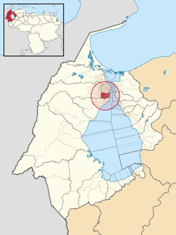
 Location of San Francisco in Zulia and Venezuela | |
| Coordinates: 10°34′N 71°38′W / 10.56°N 71.64°W | |
| Country | |
| State | Zulia |
| Created | 22 January 1995 |
| Capital | San Francisco |
| Government | |
| • Mayor | Gustavo Fernandez |
| Area | |
• Total | 185 km2 (71 sq mi) |
| Population (2011)[2] | |
• Total | 446,757 |
| • Density | 2,400/km2 (6,300/sq mi) |
| Time zone | UTC−4 (VET) |
| Website | Official website |
San Francisco is a municipality in the metropolitan area of Maracaibo, Venezuela's second largest city. San Francisco covers an area of 185 square kilometres (71 sq mi)[1] and recorded a population of 446,757 in the 2011 Venezuelan census.[2]
Geography
[edit]San Francisco is situated on the Maracaibo Plain on the west shore of Tablazo Strait, which connects Lake Maracaibo with the Caribbean Sea. It borders the municipalities of Maracaibo to the north, Jesús Enrique Lossada to the west, and La Cañada de Urdaneta to the south.[3]
San Francisco has a semi-arid climate, with an average annual temperature of 27.8 °C and annual rainfall of 700 mm.[3]
History
[edit]In his 1830 atlas of Venezuela, Agustín Codazzi recorded a Punta de San Francisco located between the towns of Maracaibo and La Cañada. San Francisco was first officially recorded as the name of a parroquia in 1881.[4] The current municipality was created on 22 January 1995 from the parroquias of San Francisco, Francisco Ochoa, Marcial Hernandez, and Domitila Flores, all previously part of the municipality of Maracaibo.[5]
Government
[edit]The following people have served as mayor (alcalde) of San Francisco:
- Saady Bijani, 1995–2008[6]
- Omar Prieto, 2008–2017
- Dirwings Arrieta, 2017–2021[7]
Subdivisions
[edit]
San Francisco is divided into seven parroquias, of which San Francisco serves as the capital of the municipality. The newest parroquia is José Domingo Rus, which was created in 2006.[5]
| Parroquia | Population (2011 census[2]) |
|---|---|
| San Francisco | 126,852 |
| El Bajo | 18,554 |
| Domitila Flores | 124,247 |
| Francisco Ochoa | 49,088 |
| Los Cortijos | 32,197 |
| Marcial Hernández | 33,248 |
| José Domingo Rus | 62,571 |
Economy
[edit]San Francisco is highly urbanized and its economy is sustained by secondary and tertiary activities.[8] Major industries include coal, oil, cement, and fish processing.[3]
Infrastructure
[edit]

San Francisco is the western terminus of the Troncal 3 highway, which crosses the Tablazo Strait over the General Rafael Urdaneta Bridge and connects Maracaibo to Coro, the capital of Falcón, and the town of Morón in Carabobo. San Francisco also lies on the Troncal 6 highway, which runs north-south through Zulia from the border crossing to Colombia at Paraguachón to La Fría in Táchira.
Intercity buses stop at the Simón Bolívar bus terminal at the interchange of Troncal 3 with Avenida 5.[9] The bus terminal is also the terminus of a circular bus route which serves San Francisco and is operated by Maracaibo's Metromara bus system.[10]
La Chinita International Airport, which serves the Maracaibo area, is located in San Francisco.
The municipality has two hospitals.[3]
Recreational areas in San Francisco include the Zulia Metropolitan Zoo and a botanical garden.[3]
References
[edit]- ^ a b "Cuadro P4. Estado Zulia. Densidad poblacional según municipio, 2012". National Institute of Statistics (Venezuela). Archived from the original on 4 June 2020. Retrieved 12 October 2020.
- ^ a b c "XIV Censo nacional de población y vivienda: Resultados por Entidad Federal y Municipio del Estado Zulia" (PDF) (in Spanish). National Institute of Statistics (Venezuela). December 2014. p. 47. Archived from the original (PDF) on 10 July 2020. Retrieved 12 October 2020.
- ^ a b c d e Municipio San Francisco (PDF) (Report) (in Spanish). Corporación de Desarrollo de la Región Zuliana. 2010. Retrieved 12 October 2020.
- ^ Fernández León, Julio (6 October 2011). "HISTORIA DEL MUNICIPIO SAN FRANCISCO (Monografía)" (in Spanish). Retrieved 12 October 2020.
- ^ a b "División Político Territorial de la República Bolivariana de Venezuela 2013" (PDF) (in Spanish). National Institute of Statistics (Venezuela). September 2013. pp. 153–154, 159. Archived from the original (PDF) on 29 May 2020.
- ^ Pulgar, Andreína (22 January 2014). "San Francisco cumple 19 años entre esperanzas y carencias" (in Spanish). La Verdad. Retrieved 12 October 2020.
- ^ "Este es el perfil de Dirwings Arrieta, el nuevo alcalde del municipio San Francisco" (in Spanish). Noticia al Día. 10 December 2017. Retrieved 12 October 2020.
- ^ Ortiz, Rosa E. (22 January 2014). "Caracterización de las Organizaciones No Gubernamentales: El caso de los municipios Maracaibo y San Francisco". Revista Venezolana de Gerencia (in Spanish). 10 (32): 652–674. Retrieved 12 October 2020.
- ^ "Terminal de San Francisco cubre rutas hacia varios estados a precios solidarios" (in Spanish). Versión Final. 8 August 2016. Retrieved 12 October 2020.
- ^ "Cuáles son las rutas de BusMetroMara TransGuajira BusUrdaneta y BusLaConcepción" (in Spanish). Notilogía. 2016. Retrieved 12 October 2020.
External links
[edit]![]() Media related to San Francisco Municipality (Zulia) at Wikimedia Commons
Media related to San Francisco Municipality (Zulia) at Wikimedia Commons


