Molenlanden
Molenlanden | |
|---|---|
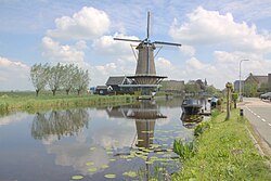
 De Vriendschap windmill in Bleskensgraaf | |
 Location in South Holland | |
 | |
| Coordinates: 51°52′N 4°47′E / 51.867°N 4.783°E | |
| Country | Netherlands |
| Province | South Holland |
| Established | 1 January 2019[1] |
| Government | |
| • Body | Municipal council |
| • Mayor | Theo Segers (Christian Union) |
| Population (1 January 2019)[2] | |
• Total | 43,858 |
| Time zone | UTC+1 (CET) |
| • Summer (DST) | UTC+2 (CEST) |
| Website | www |
Molenlanden (Dutch pronunciation: [ˈmoːlə(n)ˌlɑndə(n)]) is a municipality in the province of South Holland in the Netherlands. The municipality was created on 1 January 2019 by merging the municipalities of Giessenlanden en Molenwaard.[1] It is located east of Rotterdam along the Lek. The World Heritage Site of Kinderdijk is in the gemeente. Its largest population centers are Nieuw-Lekkerland and Giessenburg.
The municipality includes the settlements of Arkel, Bleskensgraaf, Brandwijk, De Donk, Gelkenes, Gijbeland, Giessen-Oudekerk, Giessenburg, Goudriaan, Graafland, Groot-Ammers, Hofwegen Hoogblokland, Hoornaar, Kinderdijk, Kooiwijk, Langerak, Liesveld, Molenaarsgraaf, Nieuw-Lekkerland, Nieuwpoort, Noordeloos, Ottoland, Oud-Alblas, Schelluinen, Streefkerk, Vuilendam, Waal, and Wijngaarden.
References
[edit]- ^ a b "Rectificatie nieuwe grens gemeente Molenlanden, gemeentelijke herindeling Molenwaard-Giessenlanden". Provinciaal blad van Zuid-Holland (in Dutch). No. 6319. 2018.
- ^ "Bevolkingsontwikkeling; regio per maand" [Population growth; regions per month]. CBS Statline (in Dutch). CBS. 1 January 2021. Retrieved 2 January 2022.
- ^ "Kerncijfers wijken en buurten 2020" [Key figures for neighbourhoods 2020]. StatLine (in Dutch). CBS. 24 July 2020. Retrieved 19 September 2020.


