
Latakia Governorate
Latakia Governorate
مُحافظة اللاذقية | |
|---|---|
.svg) Map of Syria with Latakia highlighted | |
| Coordinates (Latakia): 35°36′N 36°00′E / 35.6°N 36°E | |
| Country | |
| Capital | Latakia |
| Manatiq (Districts) | 4 |
| Government | |
| • Governor | Amer Ismail Hilal[1] |
| Area | |
| • Total | 2,297 km2 (887 sq mi) |
| Estimates range between 2,297 km2 and 2,437 km2 | |
| Population (2011) | |
| • Total | 1,008,000 |
| • Density | 440/km2 (1,100/sq mi) |
| Time zone | UTC+2 (EET) |
| • Summer (DST) | UTC+3 (EEST) |
| ISO 3166 code | SY-LA |
Latakia Governorate, also transliterated as Ladhakia Governorate, (Arabic: مُحافظة اللاذقية / ALA-LC: Muḥāfaẓat al-Lādhiqīyah) is one of the 14 governorates of Syria. It is situated in western Syria, bordering Turkey's Hatay Province to the north, Idlib and Hama Governorates to the east, Tartus Governorate to the south, and the Mediterranean Sea to the west. Its reported area varies in different sources from 2,297 km2 (887 sq mi)[2] to 2,437 km2 (941 sq mi).[3] The governorate has a population of 1,008,000 (2011 estimate).
History[edit]
The governorate was historically part of the Alawite State, which existed from 1920 to 1936.[4]
Tartus governorate was formerly included as part of Latakia, before being split off circa 1972.[3]
The region has been relatively peaceful during the Syrian civil war, being a generally pro-Assad region that had largely remained under government control. The Free Syrian Army attacked Al-Haffah in 2012, and unsuccessfully attempted to wrest control of the province in 2014,[5] 2015[6] and 2016.[7] In 2016 the Islamic State conducted a bomb attack on Jableh, resulting in many deaths.[8]
Archaeological sites[edit]
- Citadel of Salah Ed-Din - Ayyubid castle
- Paltus - Phoenician city
- Ugarit - Bronze Age site
Geography[edit]

The Latakia Governorate comprises about half of Syria's Mediterranean coastline. The western part of the governorate consists mainly of coastal plains, with the inland eastern parts being mountainous, with the Syrian Coastal Mountain Range (Nusayriyah Mountains) running north to south.[9] Its highest peak, Nabi Yunis, is 1,562 meters (5,125 ft) tall with the average elevation only about 1,200 meters.[9] The western areas of the governorate catch moisture-laden winds from the Mediterranean Sea and are thus more fertile and more heavily populated than the eastern slopes.
The Orontes River flows north alongside the range on its eastern verge in the Al-Ghab Plain, a 64 kilometres (40 mi) longitudinal trench,[10] and then around the northern edge of the range to flow into the Mediterranean. Another important river is Nahr al-Kabir al-Shamali, a river running from the Turkish border and to the southwest to flow in the Mediterranean, with the 16 Tishreen dam, one of the most important in the region, being constructed for power generation, storage of rain and river water, and the creation of Mashqita Lake.[11]
Cities[edit]
Latakia is the regional capital; other major settlements include Al-Haffah, Ibn Hani, Jableh, Kessab, Manjila, Qaranjah, Qardaha and Salma.
The following cities are the administrative centres of the districts in Latakia Governorate (Population based on 2004 official census):[12]
| City | Population |
|---|---|
| Latakia | 383,786 |
| Jableh | 80,000 |
| Qardaha | 8,671 |
| Al-Haffa | 4,298 |
Districts[edit]


The governorate is divided into four districts (manatiq). The districts are further divided into 22 sub-districts (nawahi):[citation needed]
|
|
Climate[edit]
| Climate data for Latakia (1961–1990, extremes 1928–present) | |||||||||||||
|---|---|---|---|---|---|---|---|---|---|---|---|---|---|
| Month | Jan | Feb | Mar | Apr | May | Jun | Jul | Aug | Sep | Oct | Nov | Dec | Year |
| Record high °C (°F) | 24.4 (75.9) |
26.3 (79.3) |
32.6 (90.7) |
35.6 (96.1) |
38.8 (101.8) |
38.4 (101.1) |
36.2 (97.2) |
38.4 (101.1) |
38.2 (100.8) |
39.0 (102.2) |
32.6 (90.7) |
28.0 (82.4) |
39.0 (102.2) |
| Mean daily maximum °C (°F) | 15.4 (59.7) |
16.4 (61.5) |
18.3 (64.9) |
21.5 (70.7) |
24.1 (75.4) |
25.8 (78.4) |
28.8 (83.8) |
29.6 (85.3) |
29.0 (84.2) |
26.3 (79.3) |
21.9 (71.4) |
17.6 (63.7) |
22.9 (73.2) |
| Daily mean °C (°F) | 11.6 (52.9) |
12.6 (54.7) |
14.8 (58.6) |
17.8 (64.0) |
20.7 (69.3) |
23.8 (74.8) |
26.3 (79.3) |
27.0 (80.6) |
25.6 (78.1) |
22.3 (72.1) |
17.5 (63.5) |
13.3 (55.9) |
19.4 (66.9) |
| Mean daily minimum °C (°F) | 8.4 (47.1) |
9.1 (48.4) |
11.0 (51.8) |
14.0 (57.2) |
17.0 (62.6) |
20.7 (69.3) |
23.7 (74.7) |
24.3 (75.7) |
21.9 (71.4) |
18.2 (64.8) |
13.8 (56.8) |
10.1 (50.2) |
16.0 (60.8) |
| Record low °C (°F) | −1.6 (29.1) |
−0.5 (31.1) |
−0.6 (30.9) |
3.9 (39.0) |
10.6 (51.1) |
11.7 (53.1) |
17.8 (64.0) |
17.2 (63.0) |
12.4 (54.3) |
8.9 (48.0) |
0.0 (32.0) |
0.0 (32.0) |
−1.6 (29.1) |
| Average precipitation mm (inches) | 185.2 (7.29) |
97.0 (3.82) |
91.5 (3.60) |
48.5 (1.91) |
22.4 (0.88) |
5.2 (0.20) |
1.3 (0.05) |
2.3 (0.09) |
8.0 (0.31) |
69.3 (2.73) |
95.5 (3.76) |
185.2 (7.29) |
811.4 (31.94) |
| Average precipitation days (≥ 1.0 mm) | 11.3 | 9.3 | 8.4 | 4.6 | 2.7 | 1.0 | 0.3 | 0.3 | 1.0 | 5.2 | 6.6 | 11.0 | 61.7 |
| Average relative humidity (%) | 63 | 62 | 65 | 68 | 72 | 74 | 74 | 73 | 68 | 62 | 57 | 65 | 67 |
| Mean monthly sunshine hours | 136.4 | 148.4 | 198.4 | 225.0 | 297.6 | 321.0 | 325.5 | 316.2 | 288.0 | 248.0 | 192.0 | 151.9 | 2,848.4 |
| Mean daily sunshine hours | 4.4 | 5.3 | 6.4 | 7.5 | 9.6 | 10.7 | 10.5 | 10.2 | 9.6 | 8.0 | 6.4 | 4.9 | 7.8 |
| Source 1: NOAA[13] | |||||||||||||
| Source 2: Deutscher Wetterdienst (humidity, 1966–1978),[14] Meteo Climat (record highs and lows)[15] | |||||||||||||
Economy[edit]

The governorate is located on the Mediterranean Sea, which gave it great economic importance, with the capital of the governorate, Latakia serving as Syria's main port. Its port was established on 12 February 1950.[16]
Its imported cargo includes clothing, construction materials, vehicles, furniture, minerals, tobacco, cotton, and food supplies such as lintels, onions, wheat, barley, dates, grains and figs; in 2008, the port handled about 8 million tons of cargo.[citation needed]
The governorate is also a popular domestic tourist destination, with the Cote d'Azur B=beach of Latakia being Syria's premier coastal resort, offering water skiing, jet skiing, and windsurfing.[17] The city contains eight hotels, two of which have five-star ratings; both the Cote d'Azur de Cham Hotel and Lé Meridien Lattiquie Hotel are located 6 kilometres (3.7 mi) north of the city, at Cote d'Azur.[citation needed] The latter hotel has 274 rooms and is the only international hotel in the city.[citation needed] Latakia is also host to numerous designer-label stores, notably on 8 Azar Street, and the heart of the city's shopping area is the series of blocks enclosed by 8 Azar Street, Yarmouk Street, and Saad Zaghloul Street in the city centre.[citation needed] Cinemas in Latakia include Ugarit Cinema, al-Kindi, and a smaller theater off al-Moutanabbi Street.[citation needed]
Demographics[edit]
As per the 2004 Syrian census the population was 879,550.[3] A 2011 UNOCHA estimate put the population at 1,008,000, though this has likely changed since the start of the war.[18]
The majority at 63% are Alawites, followed by 26% Sunni Muslim, 6% Christian, 5% Shi'ite Muslim and 0.2% Ismaili.[19]
Languages[edit]
The primary languages of the province are Arabic, Armenian and Turkish (Syrian Turkmen dialects). Arabic is spoken in all district centres of the governorate and most, if not all towns and villages surrounding them, with the North Levantine dialect mostly used. An exception is Kessab, a historically Armenian-populated town where Armenian is the primary language in it and the surrounding villages such as Sev Aghpyur, Esguran and Duzaghaj,[20] and the Turkmen Mountain where Turcoman is spoken primarily, though many Turkmen have fled the area since the start of the civil war.[21]
Gallery[edit]
-
 Map of Latakia governorate
 -
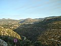 Mountains near Beit Yashout
 -
 Ruins of Ugarit
 -
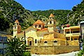 Armenian church in Kessab
 -
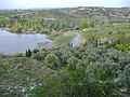 Countryside near Mushayrafet al-Samouk
 -
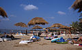 Sunbathers on the Latakian Cote d'Azur


References[edit]
- ^ "President al-Assad issues decrees appointing new governors for four Syrian provinces". SANA. 2021-11-17. Retrieved 2021-11-17.
- ^ "Syria: Governorates, Major Cities & Localities - Population Statistics, Maps, Charts, Weather and Web Information". www.citypopulation.de.
- ^ a b c "Syria Provinces". www.statoids.com.
- ^ Longrigg, Stephen Hemsley. "Syria and Lebanon Under French Mandate." London: Oxford University Press, 1958.
- ^ "Assad's forces deploy in Latakia to repel rebel offensive". Al Arabiya. Retrieved 18 May 2014.
- ^ Leith Fadel. "Syrian Army Advances North Towards the Turkish Border in Latakia: 3 Villages Captuted". Al-Masdar News. Retrieved 4 December 2015.
- ^ "Foreign jihadists advertise role in Latakia fighting". The Long War Journal. Retrieved 11 July 2016.
- ^ Philip Issa (24 May 2016). "Suicide bombing killed 43 at Syrian hospital: WHO". Global News. Retrieved 26 May 2016.
- ^ a b Federal Research Division, Library of Congress (2005) "Country Profile: Syria" page 5
- ^ "Syria - History, People, & Maps". Encyclopedia Britannica.
- ^ "المراقبة والإدارة البیئیة لنھر الكبیر الشمالي" (PDF) (in Arabic).
- ^ Latakia city population Archived 2013-03-17 at the Wayback Machine
- ^ "Latakia Climate Normals 1961–1990". National Oceanic and Atmospheric Administration. Retrieved April 26, 2017.
- ^ "Klimatafel von Lattakia / Syrien" (PDF). Baseline climate means (1961–1990) from stations all over the world (in German). Deutscher Wetterdienst. Retrieved April 26, 2017.
- ^ "Station Lattakia" (in French). Meteo Climat. Retrieved April 26, 2017.
- ^ "حول مرفأ اللاذقية - مرفأ اللاذقية". www.lattakiaport.gov.sy.
- ^ Mannheim, Ivan (2001). Syria & Lebanon Handbook: The Travel Guide. Footprint Travel Guides. p. 292. ISBN 978-1-900949-90-3.
- ^ Syrian Arab Republic - Governorates profile (PDF), UNOCHA, June 2014, retrieved 20 March 2020
- ^ Hussain Ibrahim Qutrib (2016), "Useful Syria" and Demographic Changes in Syria (PDF), King Faisal Center for Research and Islamic Studies, retrieved 20 March 2020
- ^ Mannheim, Ivan (2001). Syria and Lebanon Handbook: The Travel Guide. Footprint Travel Guides. p. 299. ISBN 1-900949-90-3.
- ^ "The regime forces the last remaining Turkmen Families to leave to Turkey". Enab Baladi. Retrieved 12 September 2016.
External links[edit]
![]() Media related to Latakia Governorate at Wikimedia Commons
Media related to Latakia Governorate at Wikimedia Commons
| Authority control databases: Geographic |
|---|