Kvikne
Kvikne Municipality
Kvikne herred | |
|---|---|
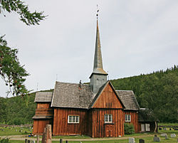
 View of the local Kvikne Church | |
 Hedmark within Norway | |
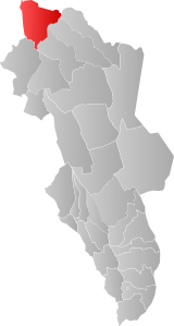
 Kvikne within Hedmark | |
| Coordinates: 62°34′56″N 10°17′14″E / 62.5823041986°N 10.28710781437°E | |
| Country | Norway |
| County | Hedmark |
| District | Østerdalen |
| Established | 1 Jan 1838 |
| • Created as | Formannskapsdistrikt |
| Disestablished | 1 Jan 1966 |
| • Succeeded by | Tynset and Rennebu |
| Administrative centre | Kvikne |
| Area (upon dissolution) | |
• Total | 1,153 km2 (445 sq mi) |
| Population (1966) | |
• Total | 1,084 |
| • Density | 0.94/km2 (2.4/sq mi) |
| Demonym | Kviknedøl[1] |
| Time zone | UTC+01:00 (CET) |
| • Summer (DST) | UTC+02:00 (CEST) |
| ISO 3166 code | NO-0440[2] |
Kvikne is a former municipality that was part of the old Hedmark county, Norway. The 1,153-square-kilometre (445 sq mi) municipality of Kvikne existed from 1838 until its dissolution in 1966 when it was split between the present-day municipalities of Tynset (in what is now Innlandet county) and Rennebu (in what is now Trøndelag county). The administrative centre of the municipality was the village of Kvikne where Kvikne Church is located.[3]
Copper mining and soapstone quarries were historically significant industries in the municipality.[3]
History
[edit]Kvikne was established as a municipality on 1 January 1838 (see formannskapsdistrikt law). During the 1960s, there were many municipal mergers across Norway due to the work of the Schei Committee. The municipality of Kvikne was dissolved on 1 January 1966 and its lands were divided into two. The 952-square-kilometre (368 sq mi) Kvikne parish in the south (population: 664) was merged into Tynset Municipality in Hedmark county and the 201-square-kilometre (78 sq mi) Innset parish in the north (population: 420) was incorporated into Rennebu Municipality in Sør-Trøndelag county. A few years later in 1970, the border was adjusted again with the Garlia farm (population: 5) being transferred from Tynset to Rennebu.[3][4][5]
Name
[edit]The municipality (originally the parish) is named Kvikne (Old Norse: Kviknar) which is an old name for the area. The name probably comes from the word kvikr which means "alive" or "lively". The name may be referring to the quick clay in the area.[3][6]
Churches
[edit]The Church of Norway had two parishes (sokn) within the municipality of Kvikne. It was part of the Nord-Østerdal prosti (deanery) in the Diocese of Hamar.
| Parish (sokn) | Church name | Location of the church | Year built |
|---|---|---|---|
| Kvikne | Kvikne Church | Yset | 1654 |
| Innset | Innset Church | Innset | 1642 (rebuilt in 2000) |
Government
[edit]While it existed, this municipality was responsible for primary education (through 10th grade), outpatient health services, senior citizen services, unemployment, social services, zoning, economic development, and municipal roads. During its existence, this municipality was governed by a municipal council of directly elected representatives. The mayor was indirectly elected by a vote of the municipal council.[7]
Municipal council
[edit]The municipal council (Herredsstyre) of Kvikne was made up of 13 representatives that were elected to four year terms. The party breakdown of the final municipal council was as follows:
| Party name (in Norwegian) | Number of representatives | |
|---|---|---|
| Labour Party (Arbeiderpartiet) | 4 | |
| Centre Party (Senterpartiet) | 7 | |
| Liberal Party (Venstre) | 2 | |
| Total number of members: | 13 | |
| Party name (in Norwegian) | Number of representatives | |
|---|---|---|
| Labour Party (Arbeiderpartiet) | 4 | |
| Centre Party (Senterpartiet) | 5 | |
| Liberal Party (Venstre) | 4 | |
| Total number of members: | 13 | |
| Party name (in Norwegian) | Number of representatives | |
|---|---|---|
| Labour Party (Arbeiderpartiet) | 4 | |
| Farmers' Party (Bondepartiet) | 6 | |
| Liberal Party (Venstre) | 3 | |
| Total number of members: | 13 | |
| Party name (in Norwegian) | Number of representatives | |
|---|---|---|
| Labour Party (Arbeiderpartiet) | 5 | |
| Farmers' Party (Bondepartiet) | 5 | |
| Liberal Party (Venstre) | 2 | |
| Total number of members: | 12 | |
| Party name (in Norwegian) | Number of representatives | |
|---|---|---|
| Labour Party (Arbeiderpartiet) | 3 | |
| Farmers' Party (Bondepartiet) | 2 | |
| Liberal Party (Venstre) | 2 | |
| Joint List(s) of Non-Socialist Parties (Borgerlige Felleslister) | 3 | |
| Local List(s) (Lokale lister) | 2 | |
| Total number of members: | 12 | |
| Party name (in Norwegian) | Number of representatives | |
|---|---|---|
| Labour Party (Arbeiderpartiet) | 4 | |
| Christian Democratic Party (Kristelig Folkeparti) | 3 | |
| Farmers' Party (Bondepartiet) | 2 | |
| Joint List(s) of Non-Socialist Parties (Borgerlige Felleslister) | 3 | |
| Total number of members: | 12 | |
| Party name (in Norwegian) | Number of representatives | |
|---|---|---|
| Labour Party (Arbeiderpartiet) | 2 | |
| Farmers' Party (Bondepartiet) | 3 | |
| Liberal Party (Venstre) | 3 | |
| Joint List(s) of Non-Socialist Parties (Borgerlige Felleslister) | 4 | |
| Total number of members: | 12 | |
| Note: Due to the German occupation of Norway during World War II, no elections were held for new municipal councils until after the war ended in 1945. | ||
Climate
[edit]| Climate data for Sæter I Kvikne 1961-1990, extremes 1933-1998 | |||||||||||||
|---|---|---|---|---|---|---|---|---|---|---|---|---|---|
| Month | Jan | Feb | Mar | Apr | May | Jun | Jul | Aug | Sep | Oct | Nov | Dec | Year |
| Record high °C (°F) | 11.8 (53.2) |
10.0 (50.0) |
13.1 (55.6) |
15.8 (60.4) |
24.1 (75.4) |
29.3 (84.7) |
27.0 (80.6) |
28.5 (83.3) |
24.7 (76.5) |
19.0 (66.2) |
12.0 (53.6) |
11.0 (51.8) |
29.3 (84.7) |
| Mean daily maximum °C (°F) | −4.6 (23.7) |
−3.6 (25.5) |
0.1 (32.2) |
4.1 (39.4) |
11.0 (51.8) |
15.4 (59.7) |
16.5 (61.7) |
15.6 (60.1) |
10.8 (51.4) |
6.0 (42.8) |
−0.5 (31.1) |
−3.0 (26.6) |
5.6 (42.2) |
| Mean daily minimum °C (°F) | −12.8 (9.0) |
−12.3 (9.9) |
−9.1 (15.6) |
−4.8 (23.4) |
1.0 (33.8) |
4.8 (40.6) |
6.6 (43.9) |
5.8 (42.4) |
2.6 (36.7) |
−0.8 (30.6) |
−7.6 (18.3) |
−11.2 (11.8) |
−3.1 (26.3) |
| Record low °C (°F) | −38.4 (−37.1) |
−36.8 (−34.2) |
−34.1 (−29.4) |
−26.6 (−15.9) |
−13.5 (7.7) |
−4.6 (23.7) |
−1.8 (28.8) |
−3.0 (26.6) |
−8.5 (16.7) |
−20.3 (−4.5) |
−35.1 (−31.2) |
−37.8 (−36.0) |
−38.4 (−37.1) |
| Average precipitation mm (inches) | 33 (1.3) |
25 (1.0) |
27 (1.1) |
23 (0.9) |
33 (1.3) |
60 (2.4) |
82 (3.2) |
65 (2.6) |
69 (2.7) |
48 (1.9) |
35 (1.4) |
35 (1.4) |
535 (21.2) |
| Average precipitation days | 8.9 | 6.9 | 7.2 | 7.1 | 7.3 | 10.8 | 13.4 | 11.9 | 13.4 | 10.5 | 9.1 | 8.8 | 115.3 |
| Source: Met Norway Eklima | |||||||||||||
See also
[edit]References
[edit]- ^ "Navn på steder og personer: Innbyggjarnamn" (in Norwegian). Språkrådet.
- ^ Bolstad, Erik; Thorsnæs, Geir, eds. (26 January 2023). "Kommunenummer". Store norske leksikon (in Norwegian). Kunnskapsforlaget.
- ^ a b c d Mæhlum, Lars, ed. (15 March 2021). "Kvikne". Store norske leksikon (in Norwegian). Kunnskapsforlaget. Retrieved 30 January 2022.
- ^ Jukvam, Dag (1999). Historisk oversikt over endringer i kommune- og fylkesinndelingen (PDF) (in Norwegian). Statistisk sentralbyrå. ISBN 9788253746845.
- ^ "Forskrift om sammenslåing av Kvikne og Tynset kommuner, Hedmark". Lovdata.no (in Norwegian). 30 April 1965. Retrieved 30 January 2022.
- ^ Rygh, Oluf (1900). Norske gaardnavne: Hedmarkens amt (in Norwegian) (3 ed.). Kristiania, Norge: W. C. Fabritius & sønners bogtrikkeri. p. 426.
- ^ Hansen, Tore; Vabo, Signy Irene, eds. (20 September 2022). "kommunestyre". Store norske leksikon (in Norwegian). Kunnskapsforlaget. Retrieved 1 January 2023.
- ^ "Kommunevalgene 1963" (PDF) (in Norwegian). Oslo: Statistisk sentralbyrå. 1964.
- ^ "Kommunevalgene og Ordførervalgene 1959" (PDF) (in Norwegian). Oslo: Statistisk sentralbyrå. 1960.
- ^ "Kommunevalgene og Ordførervalgene 1955" (PDF) (in Norwegian). Oslo: Statistisk sentralbyrå. 1957.
- ^ "Kommunevalgene og Ordførervalgene 1951" (PDF) (in Norwegian). Oslo: Statistisk sentralbyrå. 1952.
- ^ "Kommunevalgene og Ordførervalgene 1947" (PDF) (in Norwegian). Oslo: Statistisk sentralbyrå. 1948.
- ^ "Kommunevalgene og Ordførervalgene 1945" (PDF) (in Norwegian). Oslo: Statistisk sentralbyrå. 1947.
- ^ "Kommunevalgene og Ordførervalgene 1937" (PDF) (in Norwegian). Oslo: Statistisk sentralbyrå. 1938.

