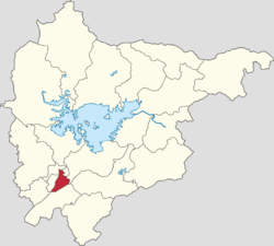
Gulou Subdistrict, Beijing
Appearance
Gulou Subdistrict
鼓楼街道 | |
|---|---|
 Government building of Miyun District within Gulou Subdistrict, 2022 | |
 Location in Miyun District | |
| Coordinates: 40°22′02″N 116°50′02″E / 40.36722°N 116.83389°E | |
| Country | China |
| Municipality | Beijing |
| District | Miyun |
| Village-level Divisions | 29 communities |
| Area | |
• Total | 13.04 km2 (5.03 sq mi) |
| Elevation | 70 m (230 ft) |
| Population (2020) | |
• Total | 154,739 |
| • Density | 12,000/km2 (31,000/sq mi) |
| Time zone | UTC+8 (China Standard) |
| Postal code | 101511 |
| Area code | 010 |
Gulou Subdistrict (simplified Chinese: 鼓楼街道; traditional Chinese: 鼓樓街道; pinyin: Gǔlóu Jiēdào) is a subdistrict and the seat of Miyun District of Beijing, China.[1] It borders Miyun Town and Tanying Ethnic Township to its north, Mujiayu Town to its east, Henanzhai Town to its south, and Guoyuan Subdistrict to its west. As of 2020, it had a population of 154,739.[2]
The subdistrict was created in 2005 from part of Miyun Town. its name Gulou (Chinese: 鼓楼; lit. 'Drum Tower') originates from the Miyun Drum Tower that used to exist within the region.[3]
Administrative divisions
[edit]Here is a list of the 29 communities under Gulou Subdistrict as of 2021:[4]
| Subdisvision Names | Name Transliterations |
|---|---|
| 白檀 | Baitan |
| 鼓楼 | Gulou |
| 鼓楼南区 | Gulou Nanqu |
| 宾阳里 | Binyangli |
| 宾阳北里 | Binyang Beili |
| 宾阳西里 | Binyang Nanli |
| 北源里 | Beiyuanli |
| 东菜园 | Dongcaiyuan |
| 行宫 | Xinggong |
| 石桥 | Shiqiao |
| 沿湖 | Yanhu |
| 车站路 | Chezhanlu |
| 车站路南区 | Chezhanlu Nanqu |
| 檀州家园 | Tanzhou Jiayuan |
| 云秀花园 | Yunxiu Huayuan |
| 宾阳 | Binyang |
| 太扬家园 | Taiyang Jiayuan |
| 行宫南区 | Xinggong Nanqu |
| 亚澜湾 | Yalanwan |
| 长安东区 | Chang'an Dongqu |
| 长安西区 | Chang'an Xiqu |
| 檀城东区 | Tancheng Dongqu |
| 檀城西区 | Tancheng Xiqu |
| 花园东区 | Huayuan Dongqu |
| 花园西区 | Huayuan Xiqu |
| 向阳西区 | Xiangyang Xiqu |
| 阳光 | Yangguang |
| 御东园 | Yudongyuan |
| 云北 | Yunbei |
Gallery
[edit]-
Miyun MIXC on the southwest of the subdistrict, 2020
-
Street corner in Gulou North Street, 2022
See also
[edit]References
[edit]- ^ "北京撤销密云县、延庆县 设立密云区、延庆区". 2015-11-17.
密云区人民政府驻鼓楼街道鼓楼西大街3号
- ^ "北京市密云区第七次全国人口普查公报". www.bjmy.gov.cn. Archived from the original on 2022-10-31. Retrieved 2022-10-31.
- ^ 李立国; 李万钧; 吴世民, eds. (2013). 中华人民共和国政区大典, 北京市卷. Beijing: 中国社会出版社. ISBN 978-7-5087-4058-4. OCLC 910451741.
- ^ "2021年统计用区划代码和城乡划分代码". www.stats.gov.cn. Retrieved 2022-10-29.


