Finland, Minnesota
Finland, Minnesota | |
|---|---|
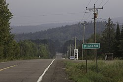
 Signpost for the community of Finland | |
| Coordinates: 47°24′53″N 91°14′57″W / 47.41472°N 91.24917°W | |
| Country | United States |
| State | Minnesota |
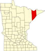
| County | Lake |
| Townships | Beaver Bay, Crystal Bay |
| Area | |
| • Total | 6.74 sq mi (17.46 km2) |
| • Land | 6.72 sq mi (17.40 km2) |
| • Water | 0.02 sq mi (0.06 km2) |
| Elevation | 1,329 ft (405 m) |
| Population | |
| • Total | 215 |
| • Density | 32.00/sq mi (12.36/km2) |
| Time zone | UTC-6 (CST) |
| • Summer (DST) | UTC-5 (CDT) |
| ZIP code | 55603 |
| Area code | 218 |
| GNIS feature ID | 656231[2] |
Finland is an unincorporated community and census-designated place (CDP) in Crystal Bay and Beaver Bay townships, Lake County, Minnesota, United States. As of the 2020 census, its population was 195.[3]
Geography
[edit]The community of Finland is located 6 miles (10 km) inland from Lake Superior's North Shore and 39 miles (63 km) northeast of the city of Two Harbors. State Highway 1, County Road 6, and County Road 7 are three of the main routes in the community. State Highway 1 continues northwest from Finland 56 miles (90 km) to Ely.
According to the United States Census Bureau, the Finland CDP has a total area of 5.4 square miles (13.9 km2), of which 0.02 square miles (0.06 km2), or 0.41%, are water.[4] The Baptism River flows through the community. George H. Crosby Manitou State Park is located 7 miles (11 km) northeast of Finland.
The community is located within the Finland State Forest in Lake County.
History
[edit]| Census | Pop. | Note | %± |
|---|---|---|---|
| 2010 | 195 | — | |
| 2020 | 215 | 10.3% | |
| U.S. Decennial Census[5] 2020 Census[3] | |||
A post office called Finland has been in operation since 1915,[6] and a cooperative general store was established in 1913, which is Minnesota's longest continuously operated store. The name of the town comes from the fact that a large portion of the early settlers were Finns.[7] The 1931 book Finlandssvenskarna i Amerika ('The Finland Swedes in America') describes the town's founding: "Two Finns, a Lindström and a Pelto, went out to the forest 40 miles north of Two Harbors a few years ago. They set about clearing forest and breaking ground. Later, a railroad was built through the new community and the place was named Finland."[8]
The visitor center is the former home of forest ranger and longtime Finland resident O. M. Eckbeck, who built it in 1927.[9]
The Lutheran church was struck by lightning on July 6, 2013, burning down as a result.[10] It was later rebuilt.
References
[edit]- ^ "2020 U.S. Gazetteer Files". United States Census Bureau. Retrieved July 24, 2022.
- ^ a b "Finland, Minnesota". Geographic Names Information System. United States Geological Survey, United States Department of the Interior.
- ^ a b c "Explore Census Data". United States Census Bureau. Retrieved August 9, 2022.
- ^ "U.S. Gazetteer Files: 2019: Places: Minnesota". U.S. Census Bureau Geography Division. Retrieved March 19, 2020.
- ^ "Census of Population and Housing". Census.gov. Retrieved June 4, 2016.
- ^ "Lake County". Jim Forte Postal History. Retrieved July 17, 2015.
- ^ Warren Upham (1920). Minnesota Geographic Names: Their Origin and Historic Significance. Minnesota Historical Society. p. 294.
- ^ Silfversten, Carl J. (1931). Finlandssvenskarna i Amerika (in Swedish). Duluth. OCLC 1153916396.
{{cite book}}: CS1 maint: location missing publisher (link), cited in "Finland". Jakobstads Tidning (in Swedish). No. 129. November 14, 1939. p. 3 – via National Library of Finland. - ^ "Visitor Center". Finland Minnesota Historical Society. February 16, 2015. Retrieved March 14, 2022.
- ^ "Fire destroys Finland's only church". Star Tribune.


