
File:Yorkshire Dales National Park UK location map.svg

Size of this PNG preview of this SVG file: 484 × 599 pixels. Other resolutions: 194 × 240 pixels | 388 × 480 pixels | 621 × 768 pixels | 828 × 1,024 pixels | 1,655 × 2,048 pixels | 1,088 × 1,346 pixels.
Original file (SVG file, nominally 1,088 × 1,346 pixels, file size: 1.18 MB)
| This is a file from the Wikimedia Commons. Information from its description page there is shown below. Commons is a freely licensed media file repository. You can help. |
| Description |
Map of the Yorkshire Dales National Park, UK with the following information shown:
|
| Date | |
| Source |
Office of National Statistics Geography
|
| Author | Nilfanion, created using Ordnance Survey data |
| Permission (Reusing this file) |
This file is licensed under the Creative Commons Attribution-Share Alike 3.0 Unported license. Attribution: Contains Ordnance Survey data © Crown copyright and database right
|
File history
Click on a date/time to view the file as it appeared at that time.
| Date/Time | Thumbnail | Dimensions | User | Comment | |
|---|---|---|---|---|---|
| current | 20:28, 18 October 2016 |  | 1,088 × 1,346 (1.18 MB) | Rcsprinter123 | 2016 amendments |
| 19:18, 30 October 2010 | 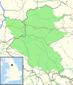 | 1,157 × 1,345 (1.14 MB) | Nilfanion | thicker counties + districts | |
| 21:42, 29 October 2010 |  | 1,157 × 1,345 (1.02 MB) | Nilfanion | {{Information |Description=Map of the Yorkshire Dales National Park, UK with the following information shown: *National Park boundary *Administrative borders *Coastline, lakes and rivers *Roads and railways *Urban areas Equirectangu |
File usage
The following pages on the English Wikipedia use this file (pages on other projects are not listed):
Global file usage
The following other wikis use this file:
- Usage on ar.wikipedia.org
- Usage on ceb.wikipedia.org
- Usage on fa.wikipedia.org
- Usage on he.wikipedia.org
- Usage on kn.wikipedia.org
- Usage on tr.wikipedia.org
- Usage on vi.wikipedia.org
- Usage on war.wikipedia.org
- Usage on zh.wikipedia.org