
File:Yeavering Bell hill fort - geograph.org.uk - 1508062.jpg

Size of this preview: 800 × 343 pixels. Other resolutions: 320 × 137 pixels | 640 × 274 pixels | 1,024 × 439 pixels | 1,280 × 549 pixels | 2,560 × 1,097 pixels | 7,580 × 3,249 pixels.
Original file (7,580 × 3,249 pixels, file size: 2.16 MB, MIME type: image/jpeg)
| This is a file from the Wikimedia Commons. Information from its description page there is shown below. Commons is a freely licensed media file repository. You can help. |
Summary
| Description |
English: Yeavering Bell hill fort This massive ruined wall encircles the twin tops of Yeavering Bell and encloses a huge area in which the large number of roundhouse remains indicate a sizeable prehistoric population. The view is north-west over the village of Kirknewton and the River Glen valley on its dog-leg between Kilham Hill and Housedon Hill |
| Date | |
| Source | From geograph.org.uk |
| Author | Andrew Curtis |
| Attribution (required by the license) | Andrew Curtis / Yeavering Bell hill fort / |
| Camera location | | View this and other nearby images on: OpenStreetMap |
|---|
| Object location | | View this and other nearby images on: OpenStreetMap |
|---|
Licensing

|
This image was taken from the Geograph project collection. See this photograph's page on the Geograph website for the photographer's contact details. The copyright on this image is owned by Andrew Curtis and is licensed for reuse under the Creative Commons Attribution-ShareAlike 2.0 license.
|
This file is licensed under the Creative Commons Attribution-Share Alike 2.0 Generic license.
Attribution: Andrew Curtis
- You are free:
- to share – to copy, distribute and transmit the work
- to remix – to adapt the work
- Under the following conditions:
- attribution – You must give appropriate credit, provide a link to the license, and indicate if changes were made. You may do so in any reasonable manner, but not in any way that suggests the licensor endorses you or your use.
- share alike – If you remix, transform, or build upon the material, you must distribute your contributions under the same or compatible license as the original.
File history
Click on a date/time to view the file as it appeared at that time.
| Date/Time | Thumbnail | Dimensions | User | Comment | |
|---|---|---|---|---|---|
| current | 22:29, 2 March 2011 | 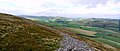 | 7,580 × 3,249 (2.16 MB) | GeographBot | == {{int:filedesc}} == {{Information |description={{en|1=Yeavering Bell hill fort This massive ruined wall encircles the twin tops of Yeavering Bell and encloses a huge area in which the large number of roundhouse remains indicate a sizeable prehistoric p |
File usage
The following pages on the English Wikipedia use this file (pages on other projects are not listed):