
File:William Faden. Composite Mediterranean. 1785.R.jpg
Size of this preview: 639 × 600 pixels. Other resolutions: 256 × 240 pixels | 512 × 480 pixels | 818 × 768 pixels | 1,218 × 1,143 pixels.
Original file (1,218 × 1,143 pixels, file size: 400 KB, MIME type: image/jpeg)
| This is a file from the Wikimedia Commons. Information from its description page there is shown below. Commons is a freely licensed media file repository. You can help. |
Summary
| Description |
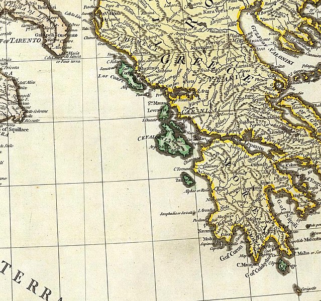
English: (Composite of) A map of the Mediterranean Sea with the adjacent regions and seas in Europe, Asia and Africa. By William Faden, Geographer to the King. London, printed for Wm. Faden, Charing Cross, March 1st, 1785. |
||||||||||||||||||||||
| Date | |||||||||||||||||||||||
| Source |
|
||||||||||||||||||||||
| Author |
|
||||||||||||||||||||||
Licensing
|
This work is in the public domain in its country of origin and other countries and areas where the copyright term is the author's life plus 100 years or fewer. | |
| This file has been identified as being free of known restrictions under copyright law, including all related and neighboring rights. | |
File history
Click on a date/time to view the file as it appeared at that time.
| Date/Time | Thumbnail | Dimensions | User | Comment | |
|---|---|---|---|---|---|
| current | 15:32, 18 July 2011 |  | 1,218 × 1,143 (400 KB) | Marcofran |
File usage
The following pages on the English Wikipedia use this file (pages on other projects are not listed):
Global file usage
The following other wikis use this file:
- Usage on es.wikipedia.org
- Usage on et.wikipedia.org
- Usage on id.wikipedia.org
- Usage on it.wikipedia.org
- Usage on ja.wikipedia.org
- Usage on sr.wikipedia.org