
File:West Yorkshire County.png

Size of this preview: 800 × 514 pixels. Other resolutions: 320 × 206 pixels | 640 × 411 pixels | 1,024 × 658 pixels | 1,280 × 823 pixels | 2,560 × 1,646 pixels | 3,276 × 2,106 pixels.
Original file (3,276 × 2,106 pixels, file size: 1.32 MB, MIME type: image/png)
| This is a file from the Wikimedia Commons. Information from its description page there is shown below. Commons is a freely licensed media file repository. You can help. |
Summary
| Description |
English: A map of the metropolitan county of West Yorkshire, England. This map highlights former and modern district boundaries (see Key for colour meaning). |
| Date | |
| Source | Own work by uploader. Content is verified at Her Majesty's Stationery Office (1974) Local Government in England and Wales: A Guide to the New System, London: HMSO ISBN: 0117508470. |
| Author | Jza84 |
| Other versions |
Derivative works of this file: |
Licensing
| I, the copyright holder of this work, release this work into the public domain. This applies worldwide. In some countries this may not be legally possible; if so: I grant anyone the right to use this work for any purpose, without any conditions, unless such conditions are required by law. |
File history
Click on a date/time to view the file as it appeared at that time.
| Date/Time | Thumbnail | Dimensions | User | Comment | |
|---|---|---|---|---|---|
| current | 22:12, 9 January 2009 | 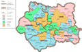 | 3,276 × 2,106 (1.32 MB) | Jza84 | alter key and its location |
| 21:36, 9 January 2009 | 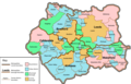 | 3,276 × 2,106 (1.34 MB) | Jza84 | {{Information |Description={{en|1=A map of West Yorkshire, highlighting former and modern district boundaries (see Key for colour meaning).}} |Source=Own work by uploader |Author=Jza84 |Date=9 January 2009 |Permission= |other_versions= }} |
File usage
The following pages on the English Wikipedia use this file (pages on other projects are not listed):
- Baildon Urban District
- Civil parishes in West Yorkshire
- Colne Valley Urban District
- County Borough of Bradford
- List of mills in Bradford
- List of mills in Bradford (metropolitan borough)
- List of mills in Calderdale
- List of mills in Holmfirth
- List of mills in Kirklees
- List of mills in Leeds
- List of mills in Wakefield
- Municipal Borough of Brighouse
- Municipal Borough of Castleford
- West Riding of Yorkshire
- West Yorkshire
- User:Skinsmoke/Sandbox/Civil parishes/West Yorkshire
- User talk:Lozleader/Archive 2
- Wikipedia:Graphics Lab/Map workshop/Archive/Dec 2010
- Category:Textile mills in West Yorkshire
Global file usage
The following other wikis use this file:
- Usage on da.wikipedia.org
- Usage on fa.wikipedia.org
- Usage on it.wikipedia.org
- Usage on pt.wikipedia.org