
File:West Point Foundry office.jpg
No higher resolution available.
West_Point_Foundry_office.jpg (647 × 460 pixels, file size: 190 KB, MIME type: image/jpeg)
| This is a file from the Wikimedia Commons. Information from its description page there is shown below. Commons is a freely licensed media file repository. You can help. |
|
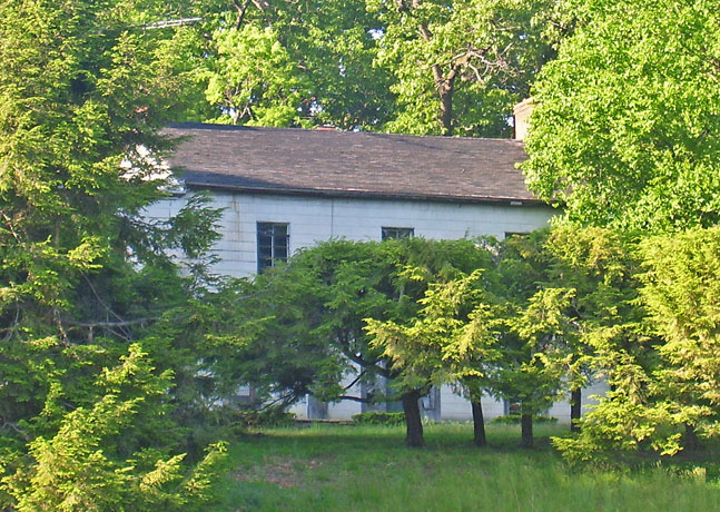
This is an image of a place or building that is listed on the National Register of Historic Places in the United States of America. Its reference number is 73001250. |
| Description | |||||||||
| Date | 29 May 2007 (original upload date) | ||||||||
| Source | Transferred from en.wikipedia to Commons by Daniel Case. | ||||||||
| Author | The original uploader was Daniel Case at English Wikipedia. | ||||||||
| Permission (Reusing this file) |
Daniel Case at the English-language Wikipedia, the copyright holder of this work, hereby publishes it under the following license:
|

| Object location | | View this and other nearby images on: OpenStreetMap |
|---|
This photo is of the William Kemble house, NOT the West Point Foundry office. William Kemble was the brother of Gouverneur Kemble, and together they founded the West Point Foundry in 1817. This house, built in the 1840s was his country estate adjacent to his brother's house, both on the edge of the WPF property.
Original upload log
The original description page was here. All following user names refer to en.wikipedia.
- 2007-05-29 04:13 Daniel Case 647×460×8 (194488 bytes) Photographed by [[User:Daniel Case|Daniel Case]] 2007-05-24 from across the [[Metro-North Railroad|Metro-North]] tracks.
File history
Click on a date/time to view the file as it appeared at that time.
| Date/Time | Thumbnail | Dimensions | User | Comment | |
|---|---|---|---|---|---|
| current | 05:58, 14 January 2008 |  | 647 × 460 (190 KB) | Daniel Case | {{Information |Description={{en|Photographed by Daniel Case 2007-05-24 from across the Metro-North tracks.}} |Source=Transferred from [http://en.wikipedia.org en.wikipedia]; Transfer was stated to be m |
File usage
The following pages on the English Wikipedia use this file (pages on other projects are not listed):
Global file usage
The following other wikis use this file:
- Usage on fr.wikipedia.org
- Usage on www.wikidata.org