
File:WatchungSubRanges.png

Size of this preview: 487 × 600 pixels. Other resolutions: 195 × 240 pixels | 500 × 616 pixels.
Original file (500 × 616 pixels, file size: 13 KB, MIME type: image/png)
| This is a file from the Wikimedia Commons. Information from its description page there is shown below. Commons is a freely licensed media file repository. You can help. |
Summary
| Description |
English: The map above uses color shading to depict the various sub ranges and ridges of the Watchung Mountains. |
| Date |
April 2009 with subsquent modifcations. |
| Source |
Created by roughly tracing a topographic map of the Watchungs with a resolution of 128 meters per pixel. This image by Lithium6ion (talk) |
| Author | Lithium6ion at English Wikipedia |
Licensing
| This work has been released into the public domain by its author, Lithium6ion at English Wikipedia. This applies worldwide. In some countries this may not be legally possible; if so: Lithium6ion grants anyone the right to use this work for any purpose, without any conditions, unless such conditions are required by law. |
Original upload log
Transferred from en.wikipedia to Commons by Magnus Manske using CommonsHelper.
The original description page was here. All following user names refer to en.wikipedia.
- 2010-01-04 01:37 Lithium6ion 500×616× (13003 bytes) Added more detail to Campgaw Mountain and southern end of Long Hill. Labeled Orange Mountain.
- 2009-09-07 18:25 Lithium6ion 500×616× (12560 bytes) 'Goffle Hill' is contemporary name for the entirety Totoway Mountain. Instances of the name 'Totoway Mountain' fall out of common use in the early 20th century.
- 2009-04-13 04:35 Lithium6ion 500×616× (12597 bytes) Reducing eye strain
- 2009-04-13 04:02 Lithium6ion 500×616× (8177 bytes) The map above uses color shading to depict the various sub ranges and ridges of the [[Watchung Mountains]]. Created by roughly tracing a topographic map of the Watchungs with a resolution of 128 meters per pixel.
File history
Click on a date/time to view the file as it appeared at that time.
| Date/Time | Thumbnail | Dimensions | User | Comment | |
|---|---|---|---|---|---|
| current | 15:12, 20 February 2011 | 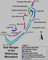 | 500 × 616 (13 KB) | File Upload Bot (Magnus Manske) | {{BotMoveToCommons|en.wikipedia|year={{subst:CURRENTYEAR}}|month={{subst:CURRENTMONTHNAME}}|day={{subst:CURRENTDAY}}}} {{Information |Description={{en|The map above uses color shading to depict the various sub ranges and ridges of the [[:en:Watchung Moun |
File usage
The following pages on the English Wikipedia use this file (pages on other projects are not listed):