
File:Waka 2001 track near Tonga.png

Size of this preview: 800 × 571 pixels. Other resolutions: 320 × 228 pixels | 640 × 457 pixels | 988 × 705 pixels.
Original file (988 × 705 pixels, file size: 241 KB, MIME type: image/png)
| This is a file from the Wikimedia Commons. Information from its description page there is shown below. Commons is a freely licensed media file repository. You can help. |
Summary
| Description |
English: Track map of Severe Tropical Cyclone Waka of the 2001–02 South Pacific cyclone season. The points show the location of the storm at 6-hour intervals. The colour represents the storm's maximum sustained wind speeds as classified in the Saffir-Simpson Hurricane Scale (see below), and the shape of the data points represent the nature of the storm, according to the legend below.
Tropical depression (≤38 mph, ≤62 km/h)
Tropical storm (39–73 mph, 63–118 km/h)
Category 1 (74–95 mph, 119–153 km/h)
Category 2 (96–110 mph, 154–177 km/h)
Category 3 (111–129 mph, 178–208 km/h)
Category 4 (130–156 mph, 209–251 km/h)
Category 5 (≥157 mph, ≥252 km/h)
Unknown
Storm type |
| Date | |
| Source | Created using Wikipedia:WikiProject Tropical cyclones/Tracks. The background image is from NASA. Tracking data is from the Joint Typhoon Warning Center and Fiji Meteorological Service [1][2]. |
| Author | Cyclonebiskit |
Licensing
| This work has been released into the public domain by its author, Cyclonebiskit. This applies worldwide. In some countries this may not be legally possible; if so: |
| This file is in the public domain in the United States because it was solely created by NASA. NASA copyright policy states that "NASA material is not protected by copyright unless noted". (See Template:PD-USGov, NASA copyright policy page or JPL Image Use Policy.) | ||
 |
Warnings:
|
File history
Click on a date/time to view the file as it appeared at that time.
| Date/Time | Thumbnail | Dimensions | User | Comment | |
|---|---|---|---|---|---|
| current | 19:08, 23 December 2010 | 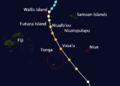 | 988 × 705 (241 KB) | Cyclonebiskit | Some adjustments and added Niuafo'ou |
| 19:01, 23 December 2010 |  | 988 × 705 (235 KB) | Cyclonebiskit | circled Tonga and added Vava'u | |
| 18:35, 23 December 2010 | 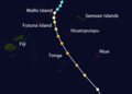 | 988 × 705 (219 KB) | Cyclonebiskit | testing out map with labels | |
| 20:52, 5 December 2010 |  | 988 × 705 (90 KB) | Cyclonebiskit | == Summary == {{Information |Description={{en|Zoomed in track map of Severe Tropical Cyclone of the 2001-02 South Pacific cyclone season near the Tongan islands. The points show |
File usage
The following pages on the English Wikipedia use this file (pages on other projects are not listed):
Global file usage
The following other wikis use this file:
- Usage on es.wikipedia.org
- Usage on zh.wikipedia.org