
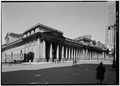
File:VIEW FROM SOUTHEAST. - Pennsylvania Station.jpg

Size of this preview: 800 × 572 pixels. Other resolutions: 320 × 229 pixels | 640 × 457 pixels | 970 × 693 pixels.
Original file (970 × 693 pixels, file size: 298 KB, MIME type: image/jpeg)
| This is a file from the Wikimedia Commons. Information from its description page there is shown below. Commons is a freely licensed media file repository. You can help. |
Summary
| English: VIEW FROM SOUTHEAST. - Pennsylvania Station
( |
|||||||||||||||||||||||
|---|---|---|---|---|---|---|---|---|---|---|---|---|---|---|---|---|---|---|---|---|---|---|---|
| Author |
|
||||||||||||||||||||||
| Title |
English: VIEW FROM SOUTHEAST. - Pennsylvania Station |
||||||||||||||||||||||
| Description |
English: 1. Historic American Buildings Survey, Cervin Robinson, Photographer May 5, 1962, VIEW FROM SOUTHEAST. - Pennsylvania Station, 370 Seventh Avenue, West Thirty-first, Thirty-first-Thirty-third Streets, New York, New York County, NY |
||||||||||||||||||||||
| Date | 8 May 1962 | ||||||||||||||||||||||
| Accession number |
HABS NY,31-NEYO,78--1 |
||||||||||||||||||||||
| Source |
|
||||||||||||||||||||||
| Other versions |
|
||||||||||||||||||||||

| Camera location | | View this and other nearby images on: OpenStreetMap |
|---|
Licensing

|
This file comes from the Historic American Buildings Survey (HABS), Historic American Engineering Record (HAER) or Historic American Landscapes Survey (HALS). These are programs of the National Park Service established for the purpose of documenting historic places. Records consist of measured drawings, archival photographs, and written reports.
|
| This image or media file contains material based on a work of a National Park Service employee, created as part of that person's official duties. As a work of the U.S. federal government, such work is in the public domain in the United States. See the NPS website and NPS copyright policy for more information. |
File history
Click on a date/time to view the file as it appeared at that time.
| Date/Time | Thumbnail | Dimensions | User | Comment | |
|---|---|---|---|---|---|
| current | 21:50, 20 July 2013 |  | 970 × 693 (298 KB) | Slowking4 |
File usage
The following pages on the English Wikipedia use this file (pages on other projects are not listed):