
File:Uruguayan railway network map-es.png

Size of this preview: 537 × 599 pixels. Other resolutions: 215 × 240 pixels | 430 × 480 pixels | 688 × 768 pixels | 918 × 1,024 pixels | 1,383 × 1,543 pixels.
Original file (1,383 × 1,543 pixels, file size: 406 KB, MIME type: image/png)
| This is a file from the Wikimedia Commons. Information from its description page there is shown below. Commons is a freely licensed media file repository. You can help. |
| Description |
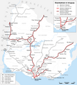
Deutsch: Karte der Eisenbahnen in Uruguay. Stand März 2010
English: Uruguayan railway network map as of March 2010
Español: Mapa del red ferroviaria de Uruguay. Situación en marzo de 2010 |
| Date | |
| Source |
Own work, using informations from these sources: (1), (2), (3), (4), (5), (6) |
| Author | Maximilian Dörrbecker (Chumwa) |
| Permission (Reusing this file) |
I, the copyright holder of this work, hereby publish it under the following license: This file is licensed under the Creative Commons Attribution-Share Alike 2.5 Generic license.
Sie dürfen das Bild zu den folgenden Bedingungen nutzen:
|
| Other versions |
|

File history
Click on a date/time to view the file as it appeared at that time.
| Date/Time | Thumbnail | Dimensions | User | Comment | |
|---|---|---|---|---|---|
| current | 19:42, 11 July 2011 |  | 1,383 × 1,543 (406 KB) | Chumwa | Joaquin Juárez → La Estanzuela |
| 11:17, 3 July 2011 |  | 1,383 × 1,543 (406 KB) | Chumwa | corr & update | |
| 05:53, 3 March 2010 |  | 1,383 × 1,543 (401 KB) | Chumwa | Doppelspurabschnitt eingetragen | |
| 06:55, 1 March 2010 | 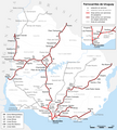 | 1,383 × 1,543 (400 KB) | Chumwa | diverse Korrekturen | |
| 06:41, 28 February 2010 | 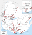 | 1,383 × 1,512 (396 KB) | Chumwa | {{Information |Description= {{de|Karte der Eisenbahnen in Uruguay}} {{en|Uruguayan railway network map}} {{es|Mapa del red ferroviaria de Uruguay}} |Source={{Own}}, using informations from these sources: (1), [[:File:Uru |
File usage
The following pages on the English Wikipedia use this file (pages on other projects are not listed):
Global file usage
The following other wikis use this file:
- Usage on ca.wikipedia.org
- Usage on de.wikipedia.org
- Usage on de.wikivoyage.org
- Usage on es.wikipedia.org
- Usage on fr.wikipedia.org
- Usage on hu.wikipedia.org
- Usage on it.wikipedia.org
- Usage on ja.wikipedia.org
- Usage on pt.wikipedia.org
- Usage on ru.wikipedia.org
- Usage on sv.wikipedia.org
- Usage on www.wikidata.org