
File:United Kingdom local elections 2019 map.svg

Size of this PNG preview of this SVG file: 573 × 600 pixels. Other resolutions: 229 × 240 pixels | 459 × 480 pixels | 734 × 768 pixels | 979 × 1,024 pixels | 1,957 × 2,048 pixels | 1,296 × 1,356 pixels.
Original file (SVG file, nominally 1,296 × 1,356 pixels, file size: 593 KB)
| This is a file from the Wikimedia Commons. Information from its description page there is shown below. Commons is a freely licensed media file repository. You can help. |
Summary
| Description |
Combination of File:English_local_elections_2015_map.svg and File:Northern Ireland local elections, 2014.svg Map showing the all of the Districts of England in 2010, coloured according to the results of the 2014 local elections. Equirectangular map projection on WGS 84 datum, with N/S stretched 170% Geographic limits: *West: 6.75W *East: 2.0E *North: 56.0N *South: 49.75N English: Legend :
No election
Pending results
Conservative
Labour
Democratic Unionist Party
Sinn Fein
Social Democratic and Labour Party
Liberal Democrat
Green
Independent
No Overall Control |
| Date | 03.5.2018 |
| Source |
This file was derived from: English districts 2010.svg:  |
| Author |
|
| This is a retouched picture, which means that it has been digitally altered from its original version. The original can be viewed here: English districts 2010.svg:
|
Licensing
I, the copyright holder of this work, hereby publish it under the following license:
This file is licensed under the Creative Commons Attribution-Share Alike 3.0 Unported license.
- You are free:
- to share – to copy, distribute and transmit the work
- to remix – to adapt the work
- Under the following conditions:
- attribution – You must give appropriate credit, provide a link to the license, and indicate if changes were made. You may do so in any reasonable manner, but not in any way that suggests the licensor endorses you or your use.
- share alike – If you remix, transform, or build upon the material, you must distribute your contributions under the same or compatible license as the original.
File history
Click on a date/time to view the file as it appeared at that time.
| Date/Time | Thumbnail | Dimensions | User | Comment | |
|---|---|---|---|---|---|
| current | 23:48, 4 May 2019 |  | 1,296 × 1,356 (593 KB) | RaviC | NI Results |
| 19:47, 3 May 2019 | 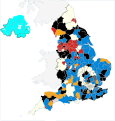 | 1,296 × 1,356 (585 KB) | Mirrorme22 | All results | |
| 09:17, 3 May 2019 |  | 1,296 × 1,356 (584 KB) | Mirrorme22 | Results | |
| 02:41, 3 May 2019 |  | 1,296 × 1,356 (582 KB) | Chipmunkdavis | Removed the Isle of Man, reduced size | |
| 08:45, 2 May 2019 |  | 1,296 × 1,356 (605 KB) | AxG | ||
| 15:21, 26 March 2019 |  | 1,296 × 1,356 (604 KB) | Maswimelleu | Updated to reflect all the councils that will not be holding elections this year, as described on the associated page. | |
| 14:47, 26 March 2019 |  | 1,296 × 1,356 (603 KB) | Maswimelleu | Updated council boundaries to reflect changes to local government authorities in Suffolk, Dorset and Somerset. Highlighted the former area of Christchurch in blue (now contested as part of new authority area). | |
| 19:39, 2 February 2019 |  | 1,296 × 1,356 (608 KB) | RaviC | Remove Bristol and Warrington (per request from Ralbegen) | |
| 11:38, 12 May 2018 | 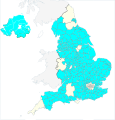 | 1,296 × 1,356 (608 KB) | Mirrorme22 | Elections will not be held in Doncaster or Rotherham as they now elect by 'all outs'. Elections will be held in Newcastle upon Tyne. | |
| 12:59, 8 May 2018 |  | 1,296 × 1,356 (608 KB) | RaviC | better layout |
File usage
The following pages on the English Wikipedia use this file (pages on other projects are not listed):
Global file usage
The following other wikis use this file:
- Usage on fa.wikipedia.org
- Usage on fr.wikipedia.org