
File:Union Baptist Church Providence RI.jpg

Size of this preview: 423 × 599 pixels. Other resolutions: 169 × 240 pixels | 339 × 480 pixels | 542 × 768 pixels | 723 × 1,024 pixels | 2,119 × 3,000 pixels.
Original file (2,119 × 3,000 pixels, file size: 3.66 MB, MIME type: image/jpeg)
| This is a file from the Wikimedia Commons. Information from its description page there is shown below. Commons is a freely licensed media file repository. You can help. |
Summary
| Description |
English: Union Baptist Church, 10 East Street, Providence Rhode Island. Apparently it had a steeple at one time. |
| Date | |
| Source | Own work |
| Author | Kenneth C. Zirkel |
| Camera location | | View this and other nearby images on: OpenStreetMap |
|---|

| Please do not upload a modified image here without consultation with the author. The author would like to make possible minor modifications only at his own source. (The source is usually a RAW file. Processing of the JPEG file means a loss of quality.) This ensures that the changes and the quality are preserved. If you think that any changes should be required, please contact the author. Otherwise you can upload a new image with a new name. Please use one of the templates Derivative or Extracted. Please enter your name too, if you upload a derivative or a detail, because you're in charge of the changes. |
Licensing
I, the copyright holder of this work, hereby publish it under the following license:
This file is licensed under the Creative Commons Attribution-Share Alike 4.0 International license.
- You are free:
- to share – to copy, distribute and transmit the work
- to remix – to adapt the work
- Under the following conditions:
- attribution – You must give appropriate credit, provide a link to the license, and indicate if changes were made. You may do so in any reasonable manner, but not in any way that suggests the licensor endorses you or your use.
- share alike – If you remix, transform, or build upon the material, you must distribute your contributions under the same or compatible license as the original.
File history
Click on a date/time to view the file as it appeared at that time.
| Date/Time | Thumbnail | Dimensions | User | Comment | |
|---|---|---|---|---|---|
| current | 17:49, 28 February 2021 | 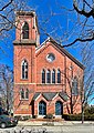 | 2,119 × 3,000 (3.66 MB) | Kzirkel | Uploaded own work with UploadWizard |
File usage
The following pages on the English Wikipedia use this file (pages on other projects are not listed):