
File:USPlanGrenadaUrgentFury.svg
Size of this PNG preview of this SVG file: 719 × 600 pixels. Other resolutions: 288 × 240 pixels | 575 × 480 pixels | 921 × 768 pixels | 1,227 × 1,024 pixels | 2,455 × 2,048 pixels | 1,020 × 851 pixels.
Original file (SVG file, nominally 1,020 × 851 pixels, file size: 655 KB)
| This is a file from the Wikimedia Commons. Information from its description page there is shown below. Commons is a freely licensed media file repository. You can help. |
Summary
| Description |
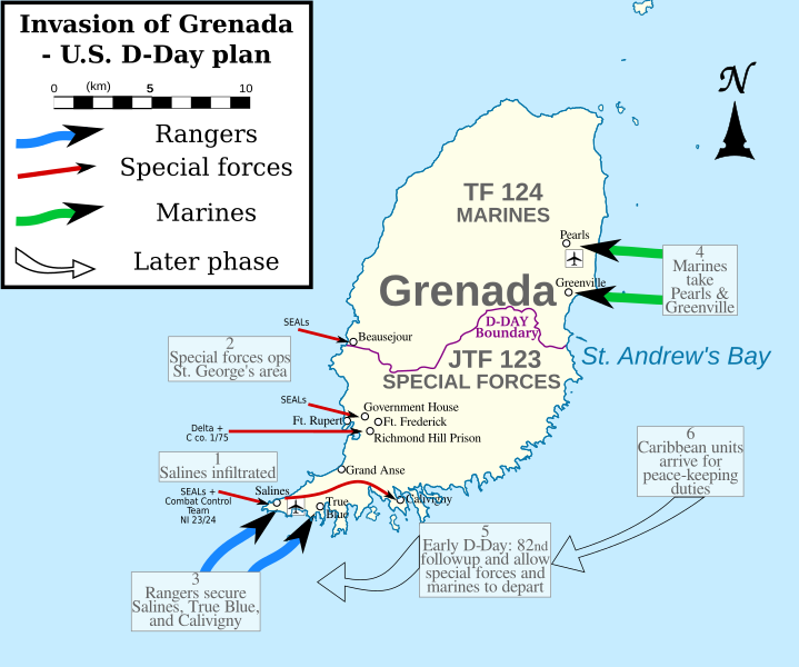
English: Image of the U.S. D-Day Plan, Invasion of Grenada: Operation Urgent Fury. |
||||||||||||
| Date | |||||||||||||
| Source |
This file was derived from: |
||||||||||||
| Author | Derfel73; NordNordWest; John M. Shalikashvili, Joint Chiefs of Staff | ||||||||||||
| Permission (Reusing this file) |
|
Licensing
This file is licensed under the Creative Commons Attribution-Share Alike 3.0 Unported license.
- You are free:
- to share – to copy, distribute and transmit the work
- to remix – to adapt the work
- Under the following conditions:
- attribution – You must give appropriate credit, provide a link to the license, and indicate if changes were made. You may do so in any reasonable manner, but not in any way that suggests the licensor endorses you or your use.
- share alike – If you remix, transform, or build upon the material, you must distribute your contributions under the same or compatible license as the original.
File history
Click on a date/time to view the file as it appeared at that time.
| Date/Time | Thumbnail | Dimensions | User | Comment | |
|---|---|---|---|---|---|
| current | 15:58, 25 October 2011 |  | 1,020 × 851 (655 KB) | Derfel73 | Corrected text (again) |
| 15:57, 25 October 2011 |  | 1,020 × 851 (638 KB) | Derfel73 | Converted text to objects | |
| 15:55, 25 October 2011 |  | 1,020 × 851 (180 KB) | Derfel73 | {{Information |Description ={{en|1=Image of the US D-Day Plan, Invasion Grenada - Operation Urgent Fury.}} |Source ={{Derived from|USPlanGrenadaUrgentFury.jpg|Grenada_location_map.svg}} |Author =Derfel73; [[User:NordNo |
File usage
The following pages on the English Wikipedia use this file (pages on other projects are not listed):
Global file usage
The following other wikis use this file:
- Usage on azb.wikipedia.org
- Usage on es.wikipedia.org
- Usage on www.wikidata.org