
File:UCERF3 fig01-b.jpg
Size of this preview: 800 × 572 pixels. Other resolutions: 320 × 229 pixels | 640 × 457 pixels | 1,024 × 732 pixels | 1,280 × 915 pixels | 2,088 × 1,492 pixels.
Original file (2,088 × 1,492 pixels, file size: 727 KB, MIME type: image/jpeg)
| This is a file from the Wikimedia Commons. Information from its description page there is shown below. Commons is a freely licensed media file repository. You can help. |
| Description |
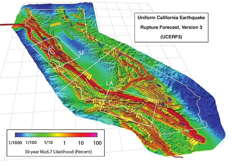
3D perspective view of California (outlined in white) and buffer zone showing the 2,606 fault sections of UCERF 3.1, with white boxes showing the San Francisco Bay (SF) and Los Angeles (LA) areas. Colors show the estimated probability of a section participating in one or more M ≥ 6.7 earthquakes in the 30 years following 2014, accounting for the current level of stress accumulated since the last earthquake. This version's scale uses percentages. Citation: WGCEP (2015-03), “UCERF3: A New Earthquake Forecast for California's Complex Fault System”, in U.S. Geological Survey[1], volume Fact Sheet 2015-3009, DOI:, ISSN 2327-6932 (online). |
|||
| Date | ||||
| Source | http://pubs.usgs.gov/fs/2015/3009/pdf/fs2015-3009.pdf | |||
| Author | Created by the WGCEP 2014 team, a collaboration of the U.S. Geological Survey, the California Geological Survey, and the Southern California Earthquake Center. | |||
| Permission (Reusing this file) |
|
File history
Click on a date/time to view the file as it appeared at that time.
| Date/Time | Thumbnail | Dimensions | User | Comment | |
|---|---|---|---|---|---|
| current | 18:59, 19 April 2016 |  | 2,088 × 1,492 (727 KB) | J. Johnson | {{Information |Description= 3D perspective view of California (outlined in white) and buffer zone showing the 2,606 fault sections of UCERF 3.1, with white boxes showing the San Francisco Bay (SF) and Los Angeles (LA) areas. Colors show the estimated p... |
File usage
The following pages on the English Wikipedia use this file (pages on other projects are not listed):
Global file usage
The following other wikis use this file:
- Usage on de.wikipedia.org
- Usage on ja.wikipedia.org
- Usage on ko.wikipedia.org
- Usage on oc.wikipedia.org
- Usage on uk.wikipedia.org