
File:Turkey vineyard map-fr.svg

Size of this PNG preview of this SVG file: 800 × 507 pixels. Other resolutions: 320 × 203 pixels | 640 × 405 pixels | 1,024 × 649 pixels | 1,280 × 811 pixels | 2,560 × 1,621 pixels | 1,579 × 1,000 pixels.
Original file (SVG file, nominally 1,579 × 1,000 pixels, file size: 323 KB)
| This is a file from the Wikimedia Commons. Information from its description page there is shown below. Commons is a freely licensed media file repository. You can help. |
Summary
| Description |
English: Map of Turkey showing the wine production regions, and the sum of temperature above the zero growth of the vine (10 ° C) from April to September. Français : Carte de la Turquie montrant les grandes régions viticoles, et la somme de température au-dessus du zéro de végétation de la vigne (10 °C) d'avril à septembre. |
| Date | (UTC) |
| Source |
|
| Author | Sémhur |
| Attribution (required by the license) | © Sémhur / Wikimedia Commons / |
| SVG development |
| Object location | | View this and other nearby images on: OpenStreetMap |
|---|
Licensing
I, the copyright holder of this work, hereby publish it under the following licenses:
| Copyleft: This work of art is free; you can redistribute it and/or modify it according to terms of the Free Art License. You will find a specimen of this license on the Copyleft Attitude site as well as on other sites. |
This file is licensed under the Creative Commons Attribution-Share Alike 4.0 International, 3.0 Unported, 2.5 Generic, 2.0 Generic and 1.0 Generic license.
- You are free:
- to share – to copy, distribute and transmit the work
- to remix – to adapt the work
- Under the following conditions:
- attribution – You must give appropriate credit, provide a link to the license, and indicate if changes were made. You may do so in any reasonable manner, but not in any way that suggests the licensor endorses you or your use.
- share alike – If you remix, transform, or build upon the material, you must distribute your contributions under the same or compatible license as the original.
You may select the license of your choice.
File history
Click on a date/time to view the file as it appeared at that time.
| Date/Time | Thumbnail | Dimensions | User | Comment | |
|---|---|---|---|---|---|
| current | 09:30, 2 June 2014 |  | 1,579 × 1,000 (323 KB) | Sémhur | Oops |
| 09:27, 2 June 2014 |  | 1,579 × 1,000 (323 KB) | Sémhur | Valid SVG | |
| 20:25, 19 May 2012 | 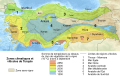 | 1,579 × 1,000 (323 KB) | Sémhur | == {{int:filedesc}} == {{Information |Description={{Multilingual description |en= Map of en:Turkey showing the wine production regions, and the sum of temperature above the zero growth of the vine (10 ° C) from April to September. |fr= Carte de ... |
File usage
The following pages on the English Wikipedia use this file (pages on other projects are not listed):
Global file usage
The following other wikis use this file:
- Usage on fr.wikipedia.org
- Usage on nl.wikipedia.org
- Usage on tr.wikipedia.org
- Usage on uk.wikipedia.org