
File:Tower, Oteley Park.jpg

Size of this preview: 396 × 599 pixels. Other resolutions: 158 × 240 pixels | 423 × 640 pixels.
Original file (423 × 640 pixels, file size: 74 KB, MIME type: image/jpeg)
| This is a file from the Wikimedia Commons. Information from its description page there is shown below. Commons is a freely licensed media file repository. You can help. |
Summary
| Description |
English: Photograph of the Tower in Oteley Park near Ellesmere, Shropshire, England. Oteley Hall (situated on the southeast shore of the Mere (lake)) was used as a Hospital during both world wars but was demolished in 1959 following a fire. The Mainwaring family still own and farm the 2,000 acre estate, part of which is open to the public. A smaller modern home was built by the Mainwaring family 100 m north of the demolished mansion.
HistoryDuring the reign of King Henry VIII, Elizabeth Oteley, the heiress of the ancient de Oteley family of Oteley in Shropshire, daughter and heiress of William Oteley, married Humphrey Kynaston who then inherited the Oteley estate. It was later inherited by the Mainwaring family, which still owns the 2,000 acre estate today (2024), although Oteley Hall was demolished in 1959 following a fire. Text amended/expanded from: shrewsburylocalhistory.org.uk[1]
|
| Date | |
| Source | https://www.geograph.org.uk/photo/3349151 |
| Author | Alan Terrill |
| Attribution (required by the license) | Alan Terrill / Folly Tower, Oteley Hall / |
| Camera location | | View this and other nearby images on: OpenStreetMap |
|---|
Licensing

|
This image was taken from the Geograph project collection. See this photograph's page on the Geograph website for the photographer's contact details. The copyright on this image is owned by Alan Terrill and is licensed for reuse under the Creative Commons Attribution-ShareAlike 2.0 license.
|
This file is licensed under the Creative Commons Attribution-Share Alike 2.0 Generic license.
Attribution: Alan Terrill
- You are free:
- to share – to copy, distribute and transmit the work
- to remix – to adapt the work
- Under the following conditions:
- attribution – You must give appropriate credit, provide a link to the license, and indicate if changes were made. You may do so in any reasonable manner, but not in any way that suggests the licensor endorses you or your use.
- share alike – If you remix, transform, or build upon the material, you must distribute your contributions under the same or compatible license as the original.
File history
Click on a date/time to view the file as it appeared at that time.
| Date/Time | Thumbnail | Dimensions | User | Comment | |
|---|---|---|---|---|---|
| current | 10:35, 25 February 2019 | 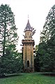 | 423 × 640 (74 KB) | Peter I. Vardy | User created page with UploadWizard |
File usage
The following pages on the English Wikipedia use this file (pages on other projects are not listed):