
File:Thomas Lee House, East Lyme (New London County, Connecticut).jpg

Size of this preview: 800 × 554 pixels. Other resolutions: 320 × 221 pixels | 640 × 443 pixels | 964 × 667 pixels.
Original file (964 × 667 pixels, file size: 358 KB, MIME type: image/jpeg)
| This is a file from the Wikimedia Commons. Information from its description page there is shown below. Commons is a freely licensed media file repository. You can help. |
|
This is an image of a place or building that is listed on the National Register of Historic Places in the United States of America. Its reference number is 70000693. |
| Description |
English: Thomas Lee House, East Lyme (New London County, Connecticut). |
|||||
| Date | ||||||
| Source |
|
|||||
| Author | Stanley P. Mixon | |||||
| Permission (Reusing this file) |
|


| Object location | | View this and other nearby images on: OpenStreetMap |
|---|
File history
Click on a date/time to view the file as it appeared at that time.
| Date/Time | Thumbnail | Dimensions | User | Comment | |
|---|---|---|---|---|---|
| current | 00:24, 12 August 2013 | 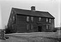 | 964 × 667 (358 KB) | ALH | higher resolution |
| 20:05, 29 December 2009 |  | 594 × 413 (68 KB) | KudzuVine | {{Information |Description={{en|1=Thomas Lee House, East Lyme (New London County, Connecticut) cropped {{PD-US-Gov-Interior-HABS|ONN,6-LYME,4-8}}}} |Source=http://memory.loc.gov/cgi-bin/displayPhoto.pl?path=/pnp/habshaer/ct/ct0400/ct0421/photos&topImages= |
File usage
The following pages on the English Wikipedia use this file (pages on other projects are not listed):
Global file usage
The following other wikis use this file:
- Usage on es.wikipedia.org
- Usage on fa.wikipedia.org
- Usage on fr.wikipedia.org
- Usage on it.wikipedia.org
- Usage on www.wikidata.org