
File:Thirteencolonies politics cropped.jpg
Size of this preview: 491 × 600 pixels. Other resolutions: 196 × 240 pixels | 393 × 480 pixels | 629 × 768 pixels | 838 × 1,024 pixels | 1,677 × 2,048 pixels | 3,685 × 4,500 pixels.
Original file (3,685 × 4,500 pixels, file size: 3.05 MB, MIME type: image/jpeg)
| This is a file from the Wikimedia Commons. Information from its description page there is shown below. Commons is a freely licensed media file repository. You can help. |
Summary
| Description |
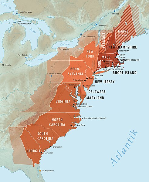
English: Thirteen colonies in North America: political organization and location of individual colonies.
New England Colonies
Middle Atlantic Colonies
Southern Colonies
Color indicated = area of today's states.(Cropped version of "Thirteencolonies politics.jpg") Deutsch: Dreizehn Kolonien in Nordamerika: politische Gliederung und Lage der Einzelkolonien.
Neuengland-Kolonien
Mittelatlantik-Kolonien
Südliche Kolonien
Farbe angedeutet = Gebiet heutige Bundesstaaten.(Ausschnitt von "Deutsch: Dreizehn Kolonien in Nordamerika: politische Gliederung und Lage der Einzelkolonien.) |
| Source | Richard Zietz |
| Author | Richard Zietz |
English: Shaded relief in background = maps-for-free.com. Deutsch: Hintergrund-Schummerung = maps-for-free.com.
Licensing
I, the copyright holder of this work, hereby publish it under the following license:
This file is licensed under the Creative Commons Attribution-Share Alike 3.0 Unported license.
- You are free:
- to share – to copy, distribute and transmit the work
- to remix – to adapt the work
- Under the following conditions:
- attribution – You must give appropriate credit, provide a link to the license, and indicate if changes were made. You may do so in any reasonable manner, but not in any way that suggests the licensor endorses you or your use.
- share alike – If you remix, transform, or build upon the material, you must distribute your contributions under the same or compatible license as the original.
File history
Click on a date/time to view the file as it appeared at that time.
| Date/Time | Thumbnail | Dimensions | User | Comment | |
|---|---|---|---|---|---|
| current | 17:02, 4 April 2024 |  | 3,685 × 4,500 (3.05 MB) | Zietz | Rechtschreibfehler korrigiert / Minimalkorrektur Schönheitsfehler |
| 10:12, 18 July 2018 |  | 3,685 × 4,500 (3.05 MB) | Zietz | Maryland = Middle Atlantic Colony --> other colour | |
| 11:46, 5 December 2017 |  | 3,685 × 4,500 (3.04 MB) | Zietz | {{Information |Description ={{en|1=Thirteen colonies in North America: political organization and location of individual colonies. Dark Red = New England Colonies. Bright Red = Middle Atlantic Colonies. Red-brown = Southern Colonies. Color indicated... |
File usage
The following pages on the English Wikipedia use this file (pages on other projects are not listed):
Global file usage
The following other wikis use this file:
- Usage on de.wikipedia.org
- Portal:Frühe Neuzeit/Exzellente Artikel
- Dreizehn Kolonien
- Europäische Expansion
- Geschichte der Dreizehn Kolonien
- Wikipedia Diskussion:Hauptseite/Artikel des Tages/Archiv/Vorschläge/2018/Q3
- Wikipedia:Hauptseite/Archiv/18. Juli 2018
- Benutzer:HajjiBaba/Verfassungskonvent der Vereinigten Staaten
- Seegefecht bei Barbados
- Usage on eo.wikipedia.org
- Usage on es.wikipedia.org
- Usage on hu.wikipedia.org
- Usage on it.wikipedia.org
- Usage on ru.wikipedia.org
- Usage on sv.wikipedia.org
- Usage on tl.wikipedia.org
- Usage on tr.wikipedia.org
- Usage on tum.wikipedia.org