
File:The high bridge, Hunningham - geograph.org.uk - 1658756.jpg
No higher resolution available.
The_high_bridge,_Hunningham_-_geograph.org.uk_-_1658756.jpg (640 × 480 pixels, file size: 106 KB, MIME type: image/jpeg)
| This is a file from the Wikimedia Commons. Information from its description page there is shown below. Commons is a freely licensed media file repository. You can help. |
Summary
| Description |
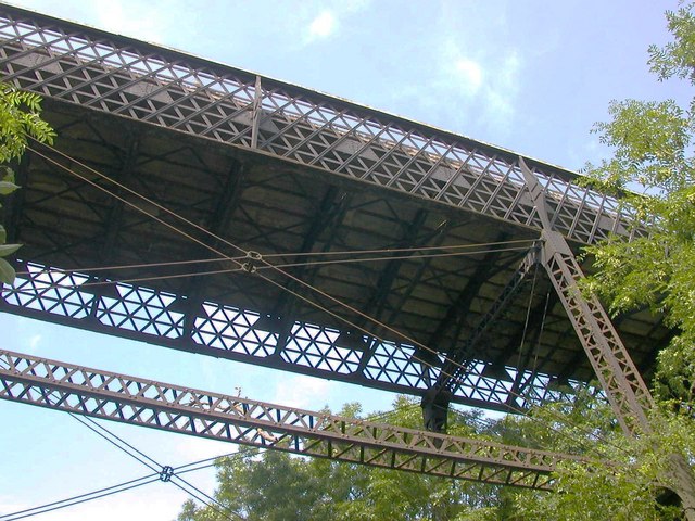
English: Underside of the high bridge, Hunningham, Warwickshire. The bridge carries Ridgeway Lane, now a county unclassified unmetalled road, over the route of the dismantled Rugby to Leamington railway. The cutting, about 60 feet deep, took the railway through a ridge between Hunningham Hill and Snowford. The single-span wrought-iron bridge is formed of lattice trusses. When built in 1851 it was the longest such bridge ever built. Later, four lattice columns and cross-ties were added to reinforce it. |
| Date | |
| Source | From geograph.org.uk |
| Author | Ian Rob |
| Attribution (required by the license) | Ian Rob / The high bridge, Hunningham / |
| Camera location | | View this and other nearby images on: OpenStreetMap |
|---|
| Object location | | View this and other nearby images on: OpenStreetMap |
|---|
Licensing

|
This image was taken from the Geograph project collection. See this photograph's page on the Geograph website for the photographer's contact details. The copyright on this image is owned by Ian Rob and is licensed for reuse under the Creative Commons Attribution-ShareAlike 2.0 license.
|
This file is licensed under the Creative Commons Attribution-Share Alike 2.0 Generic license.
Attribution: Ian Rob
- You are free:
- to share – to copy, distribute and transmit the work
- to remix – to adapt the work
- Under the following conditions:
- attribution – You must give appropriate credit, provide a link to the license, and indicate if changes were made. You may do so in any reasonable manner, but not in any way that suggests the licensor endorses you or your use.
- share alike – If you remix, transform, or build upon the material, you must distribute your contributions under the same or compatible license as the original.
File history
Click on a date/time to view the file as it appeared at that time.
| Date/Time | Thumbnail | Dimensions | User | Comment | |
|---|---|---|---|---|---|
| current | 22:29, 4 March 2011 |  | 640 × 480 (106 KB) | GeographBot | == {{int:filedesc}} == {{Information |description={{en|1=The high bridge, Hunningham The underside of the bridge.The bridge carries an ancient track called Ridgeway Lane (now a county unclassified unmetalled road) over the now-dismantled Rugby to Leamingt |
File usage
The following pages on the English Wikipedia use this file (pages on other projects are not listed):