
File:The Old Windmill at Highgate, Walsall - geograph.org.uk - 134178.jpg

No higher resolution available.
The_Old_Windmill_at_Highgate,_Walsall_-_geograph.org.uk_-_134178.jpg (640 × 480 pixels, file size: 84 KB, MIME type: image/jpeg)
| This is a file from the Wikimedia Commons. Information from its description page there is shown below. Commons is a freely licensed media file repository. You can help. |
Summary
| Description |
English: The Old Windmill at Highgate, Walsall. This old mill was built in the early 19th century. Its sails have long gone and the top of it has been altered as can be seen. It was once used as an amateur astronomical observatory and during the last war was manned every night by local air raid wardens as it was the highest point in the area. It can be seen from the top of Highgate Road which used to be called Windmill Lane. The area is generally known as 'The Windmill'. |
| Date | |
| Source | From geograph.org.uk |
| Author | Frank Smith |
| Attribution (required by the license) | Frank Smith / The Old Windmill at Highgate, Walsall / |
| Camera location | | View this and other nearby images on: OpenStreetMap |
|---|
| Object location | | View this and other nearby images on: OpenStreetMap |
|---|
Licensing

|
This image was taken from the Geograph project collection. See this photograph's page on the Geograph website for the photographer's contact details. The copyright on this image is owned by Frank Smith and is licensed for reuse under the Creative Commons Attribution-ShareAlike 2.0 license.
|
This file is licensed under the Creative Commons Attribution-Share Alike 2.0 Generic license.
Attribution: Frank Smith
- You are free:
- to share – to copy, distribute and transmit the work
- to remix – to adapt the work
- Under the following conditions:
- attribution – You must give appropriate credit, provide a link to the license, and indicate if changes were made. You may do so in any reasonable manner, but not in any way that suggests the licensor endorses you or your use.
- share alike – If you remix, transform, or build upon the material, you must distribute your contributions under the same or compatible license as the original.
File history
Click on a date/time to view the file as it appeared at that time.
| Date/Time | Thumbnail | Dimensions | User | Comment | |
|---|---|---|---|---|---|
| current | 06:47, 31 January 2010 | 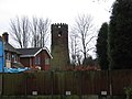 | 640 × 480 (84 KB) | GeographBot | == {{int:filedesc}} == {{Information |description={{en|1=The Old Windmill at Highgate, Walsall. This old mill was built in the early 19th century. Its sails have long gone and the top of it has been altered as can be seen. It was once used as an amateur |
File usage
The following pages on the English Wikipedia use this file (pages on other projects are not listed):
Global file usage
The following other wikis use this file:
- Usage on www.wikidata.org