
File:The Burns headstone - geograph.org.uk - 918274.jpg

Original file (427 × 640 pixels, file size: 128 KB, MIME type: image/jpeg)
| This is a file from the Wikimedia Commons. Information from its description page there is shown below. Commons is a freely licensed media file repository. You can help. |
Summary
| Description |
English: The Burns headstone The mother, brother and sister of the poet Robert Burns are buried in Bolton Parish Kirkyard within this railed enclosure. This stone was erected by Gilbert Burns in memory of his children. Gilbert, a brother of Robert Burns, was an elder of the kirk. The inscription reads:-
ERECTED By GILBERT BURNS, Factor at Grants Braes, In Memory of his Children ISABELLA, who died 3rd July 1815, in the 7th year of her age, AGNES, who died 14th Septr 1815, in the 15th year of her age, JANET, who died 30th Octor 1816 in the 18th year of her age; And of his Mother, AGNES BROWN, who died 14 Janry 1820, in the 88th year of her age; whose mortal remains lie all buried here. Also of other two of his Children VIZ. JEAN, who died on the 4th of Jany 1827, in the 20th year of her age. and JOHN, who died on the 26th Feby 1827, in the 25th year of his age. GILBERT BURNS their Father died on the 8th April 1827 in the 67th year of his age. Also buried here, ANABELLA, sister of GILBERT BURNS, who died March 2nd 1832 Aged 67. |
| Date | |
| Source | From geograph.org.uk |
| Author | Walter Baxter |
| Attribution (required by the license) | Walter Baxter / The Burns headstone / |
| Camera location | | View this and other nearby images on: OpenStreetMap |
|---|
| Object location | | View this and other nearby images on: OpenStreetMap |
|---|
Licensing

|
This image was taken from the Geograph project collection. See this photograph's page on the Geograph website for the photographer's contact details. The copyright on this image is owned by Walter Baxter and is licensed for reuse under the Creative Commons Attribution-ShareAlike 2.0 license.
|
- You are free:
- to share – to copy, distribute and transmit the work
- to remix – to adapt the work
- Under the following conditions:
- attribution – You must give appropriate credit, provide a link to the license, and indicate if changes were made. You may do so in any reasonable manner, but not in any way that suggests the licensor endorses you or your use.
- share alike – If you remix, transform, or build upon the material, you must distribute your contributions under the same or compatible license as the original.
File history
Click on a date/time to view the file as it appeared at that time.
| Date/Time | Thumbnail | Dimensions | User | Comment | |
|---|---|---|---|---|---|
| current | 00:14, 22 February 2011 | 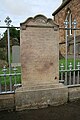 | 427 × 640 (128 KB) | GeographBot | == {{int:filedesc}} == {{Information |description={{en|1=The Burns headstone The mother, brother and sister of the poet Robert Burns are buried in Bolton Parish Kirkyard within this railed enclosure. This stone was erected by Gilbert Burns in memory of hi |
File usage
Global file usage
The following other wikis use this file:
- Usage on es.wikipedia.org
- Usage on www.wikidata.org