
File:Thameenmap3.jpg

Size of this preview: 446 × 599 pixels. Other resolutions: 179 × 240 pixels | 357 × 480 pixels | 572 × 768 pixels | 763 × 1,024 pixels | 1,525 × 2,048 pixels | 3,429 × 4,604 pixels.
Original file (3,429 × 4,604 pixels, file size: 2.35 MB, MIME type: image/jpeg)
| This is a file from the Wikimedia Commons. Information from its description page there is shown below. Commons is a freely licensed media file repository. You can help. |
Summary
| Description |
English: Map of the West Bank. |
|||
| Date | ||||
| Source |
From CIA World Fact Book |
|||
| Author | CIA | |||
| Permission (Reusing this file) |
|
|||
| Other versions |
|


Original upload log
The original description page was here. All following user names refer to en.wikipedia.
- 2006-04-14 17:01 Thameen 3429×4604× (2468750 bytes) map of the West Bank, From CIA World Fact Book
File history
Click on a date/time to view the file as it appeared at that time.
| Date/Time | Thumbnail | Dimensions | User | Comment | |
|---|---|---|---|---|---|
| current | 07:30, 16 May 2014 | 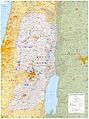 | 3,429 × 4,604 (2.35 MB) | Rcbutcher | Transferred from en.wikipedia |
File usage
The following pages on the English Wikipedia use this file (pages on other projects are not listed):
Global file usage
The following other wikis use this file:
- Usage on ar.wikipedia.org
- Usage on hi.wikipedia.org
- Usage on kn.wikipedia.org
- Usage on uk.wikipedia.org