
File:Symphyotrichum carnerosanum distribution.png

Size of this preview: 800 × 560 pixels. Other resolutions: 320 × 224 pixels | 640 × 448 pixels | 1,024 × 717 pixels | 1,450 × 1,015 pixels.
Original file (1,450 × 1,015 pixels, file size: 463 KB, MIME type: image/png)
| This is a file from the Wikimedia Commons. Information from its description page there is shown below. Commons is a freely licensed media file repository. You can help. |
Summary
| Description |
English: Symphyotrichum carnerosanum native distribution: Coahuila, Nuevo León, and Tamaulipas (Mexico). Data source: https://powo.science.kew.org/taxon/urn:lsid:ipni.org:names:981781-1 |
| Date | (UTC) |
| Source |
This file was derived from: Blank map of Mexico with states names.svg: |
| Author |
|
| This is a retouched picture, which means that it has been digitally altered from its original version. Modifications: Symphyotrichum carnerosanum distribution shaded green. The original can be viewed here: Blank map of Mexico with states names.svg:
|
Licensing
I, the copyright holder of this work, hereby publish it under the following license:
This file is licensed under the Creative Commons Attribution-Share Alike 3.0 Unported license.
- You are free:
- to share – to copy, distribute and transmit the work
- to remix – to adapt the work
- Under the following conditions:
- attribution – You must give appropriate credit, provide a link to the license, and indicate if changes were made. You may do so in any reasonable manner, but not in any way that suggests the licensor endorses you or your use.
- share alike – If you remix, transform, or build upon the material, you must distribute your contributions under the same or compatible license as the original.
Original upload log
This image is a derivative work of the following images:
- File:Blank map of Mexico with states names.svg licensed with Cc-by-sa-3.0
- 2013-03-30T21:00:56Z Isiltasuna~commonswiki 976x655 (274887 Bytes) User created page with UploadWizard
Uploaded with derivativeFX
File history
Click on a date/time to view the file as it appeared at that time.
| Date/Time | Thumbnail | Dimensions | User | Comment | |
|---|---|---|---|---|---|
| current | 10:46, 11 September 2021 |  | 1,450 × 1,015 (463 KB) | Eewilson | Cropped 4 % horizontally using CropTool with precise mode. |
| 02:49, 29 August 2021 | 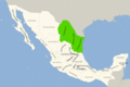 | 1,514 × 1,015 (551 KB) | Eewilson | == {{int:filedesc}} == {{Information |Description={{Multilingual description |en=Map of Mexico with the names of each mexican states. The work is bases on the map of Alexis Rojas. |es=Mapa de México con los nombres de los distritos mexicanos El trabajo está basado en el trabajo de Alexis Rojas. |eu=Mexikoko mapa mexikar estatuen izenekin. Lan hau Alexis Rojas-en lanean oinarrituta dago. }} |date=2013-... |
File usage
The following pages on the English Wikipedia use this file (pages on other projects are not listed):
Global file usage
The following other wikis use this file:
- Usage on ceb.wikipedia.org
- Usage on species.wikimedia.org
- Usage on www.wikidata.org