
File:Swansea geograph-3791275-by-Ben-Brooksbank.jpg

Size of this preview: 800 × 401 pixels. Other resolutions: 320 × 160 pixels | 640 × 320 pixels | 1,024 × 513 pixels | 1,280 × 641 pixels | 2,345 × 1,174 pixels.
Original file (2,345 × 1,174 pixels, file size: 2.53 MB, MIME type: image/jpeg)
| This is a file from the Wikimedia Commons. Information from its description page there is shown below. Commons is a freely licensed media file repository. You can help. |
Summary
| Description |
English: Swansea: Lodge of Sketty Hall at intersection of Sketty Lane and Mumbles Road. View NW, off the A4067 Mumbles Road at the A4216 Sketty Lane. This was mistakenly guessed as the site of the ex-LNWR Mumbles Road station, the last before the terminus at Swansea Victoria of the final section from Pontardulais (closed 15/6/64) of the Central Wales route from (Shrewsbury) - Craven Arms via Llandrindod Wells and Llandovery, the 'Heart of Wales' line on which since that date trains have run to Swansea High Street via Llanelli. This station had in fact been at the intersection of B4436 at Black Pill, about ½-mile further SW in SS6190, but in 2004 there was no sign whatever of the old railway. (The Swansea & Mumbles Tramway used to parallel the Mumbles Road on its eastward side beside the Bay). |
| Date | |
| Source | From geograph.org.uk |
| Author | Ben Brooksbank |
| Permission (Reusing this file) |
Creative Commons Attribution Share-alike license 2.0 |
| Attribution (required by the license) | Ben Brooksbank / Swansea: Lodge of Sketty Hall at intersection of Sketty Lane and Mumbles Road / |
| Camera location | | View this and other nearby images on: OpenStreetMap |
|---|
Licensing

|
This image was taken from the Geograph project collection. See this photograph's page on the Geograph website for the photographer's contact details. The copyright on this image is owned by Ben Brooksbank and is licensed for reuse under the Creative Commons Attribution-ShareAlike 2.0 license.
|
This file is licensed under the Creative Commons Attribution-Share Alike 2.0 Generic license.
Attribution: Ben Brooksbank
- You are free:
- to share – to copy, distribute and transmit the work
- to remix – to adapt the work
- Under the following conditions:
- attribution – You must give appropriate credit, provide a link to the license, and indicate if changes were made. You may do so in any reasonable manner, but not in any way that suggests the licensor endorses you or your use.
- share alike – If you remix, transform, or build upon the material, you must distribute your contributions under the same or compatible license as the original.
File history
Click on a date/time to view the file as it appeared at that time.
| Date/Time | Thumbnail | Dimensions | User | Comment | |
|---|---|---|---|---|---|
| current | 16:04, 12 January 2014 | 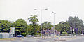 | 2,345 × 1,174 (2.53 MB) | Chevin | == {{int:filedesc}} == {{Information |Description={{en|1='''Swansea: Lodge of Sketty Hall at intersection of Sketty Lane and Mumbles Road.'''<br/> View NW, off the A4067 Mumbles Road at the B4216 Sketty Lane. This was mistakenly guessed as the site of... |
File usage
The following pages on the English Wikipedia use this file (pages on other projects are not listed):