
File:Sugarloafkeybattower.jpg

Size of this preview: 450 × 600 pixels. Other resolutions: 180 × 240 pixels | 360 × 480 pixels | 576 × 768 pixels | 768 × 1,024 pixels | 1,920 × 2,560 pixels.
Original file (1,920 × 2,560 pixels, file size: 2.32 MB, MIME type: image/jpeg)
| This is a file from the Wikimedia Commons. Information from its description page there is shown below. Commons is a freely licensed media file repository. You can help. |
|
This is an image of a place or building that is listed on the National Register of Historic Places in the United States of America. Its reference number is 82002377. |
Summary
| Description |
English: Digital photo taken by Marc Averette.
Historic bat tower on Lower Sugarloaf Key, Florida. Marc Averette 18:45, 3 November 2006 (UTC) |
| Date | 3 November 2006 (original upload date) |
| Source |
Own work Transferred from en.wikipedia |
| Author | Averette at en.wikipedia |
| Object location | | View this and other nearby images on: OpenStreetMap |
|---|
Licensing
Averette at en.wikipedia, the copyright holder of this work, hereby publishes it under the following license:
This file is licensed under the Creative Commons Attribution 3.0 Unported license.
Attribution: Averette at en.wikipedia
- You are free:
- to share – to copy, distribute and transmit the work
- to remix – to adapt the work
- Under the following conditions:
- attribution – You must give appropriate credit, provide a link to the license, and indicate if changes were made. You may do so in any reasonable manner, but not in any way that suggests the licensor endorses you or your use.
Original upload log
The original description page was here. All following user names refer to en.wikipedia.
- 2006-11-03 18:45 Averette 1280×960 (170201 bytes) Digital photo taken by Marc Averette. Historic bat tower on [[Lower Sugarloaf Key]], [[Florida]]. {{pd-self}} ~~~~
- 2008-06-25 16:00 Averette 1920×2560 (2434921 bytes) Digital photo taken by Marc Averette. The [[Sugarloaf Key bat tower]] in the [[Florida Keys]] 6/23/2008 {{self|cc-by-sa-3.0|GFDL}}
File history
Click on a date/time to view the file as it appeared at that time.
| Date/Time | Thumbnail | Dimensions | User | Comment | |
|---|---|---|---|---|---|
| current | 18:36, 9 January 2012 |  | 1,920 × 2,560 (2.32 MB) | OgreBot | (BOT): Reverting to most recent version before archival |
| 18:36, 9 January 2012 | 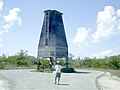 | 1,280 × 960 (166 KB) | OgreBot | (BOT): Uploading old version of file from en.wikipedia; originally uploaded on 2006-11-03 18:45:28 by Averette | |
| 08:44, 9 January 2012 | 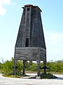 | 1,920 × 2,560 (2.32 MB) | BotMultichillT | {{BotMoveToCommons|en.wikipedia|year={{subst:CURRENTYEAR}}|month={{subst:CURRENTMONTHNAME}}|day={{subst:CURRENTDAY}}}} == {{int:filedesc}} == {{Information |description={{en|1=Digital photo taken by Marc Averette. Historic bat tower on [[:en:Lower Sugarl |
File usage
The following pages on the English Wikipedia use this file (pages on other projects are not listed):