
File:St Peter's parish war memorial, Courtlands Avenue, Lee.jpg

No higher resolution available.
St_Peter's_parish_war_memorial,_Courtlands_Avenue,_Lee.jpg (384 × 512 pixels, file size: 126 KB, MIME type: image/jpeg)
| This is a file from the Wikimedia Commons. Information from its description page there is shown below. Commons is a freely licensed media file repository. You can help. |
Summary
| Description |
English: St Peter's parish war memorial, Courtlands Avenue, Eltham, London SE12. Erected in 1920 as a First World War monument. A bronze plaque commemorating the dead of the Second World War was added later. St Peter's church was damaged by enemy action in 1941 and demolished in 1960. The block of flats in the background is on part of the site of the church. |
| Date | Taken on 26 February 2009 |
| Source |
This file was derived from: St Peter's parish war memorial, Courtlands Avenue, Lee - geograph.org.uk - 1183156.jpg |
| Author | Stephen Craven |
| Other versions | |
| Attribution (required by the license) | Stephen Craven / St Peter's parish war memorial, Courtlands Avenue, Lee / |

| Camera location | | View this and other nearby images on: OpenStreetMap |
|---|
| Object location | | View this and other nearby images on: OpenStreetMap |
|---|
Licensing
This file is licensed under the Creative Commons Attribution-Share Alike 2.0 Generic license.
Attribution: Stephen Craven
- You are free:
- to share – to copy, distribute and transmit the work
- to remix – to adapt the work
- Under the following conditions:
- attribution – You must give appropriate credit, provide a link to the license, and indicate if changes were made. You may do so in any reasonable manner, but not in any way that suggests the licensor endorses you or your use.
- share alike – If you remix, transform, or build upon the material, you must distribute your contributions under the same or compatible license as the original.
File history
Click on a date/time to view the file as it appeared at that time.
| Date/Time | Thumbnail | Dimensions | User | Comment | |
|---|---|---|---|---|---|
| current | 19:32, 18 December 2021 | 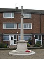 | 384 × 512 (126 KB) | Ham II | File:St Peter's parish war memorial, Courtlands Avenue, Lee - geograph.org.uk - 1183156.jpg cropped 20 % horizontally, 20 % vertically using CropTool with precise mode. |
File usage
The following pages on the English Wikipedia use this file (pages on other projects are not listed):