
File:St Martin's Church, Brighouse - geograph.org.uk - 150077.jpg

No higher resolution available.
St_Martin's_Church,_Brighouse_-_geograph.org.uk_-_150077.jpg (640 × 473 pixels, file size: 126 KB, MIME type: image/jpeg)
| This is a file from the Wikimedia Commons. Information from its description page there is shown below. Commons is a freely licensed media file repository. You can help. |
Summary
| Description |
English: St Martin's Church, Brighouse This church was first built in 1831-2, and had seating for 1100 people. Part of the cost was met by the government under the 'Million Act', which provided for the erection of churches in the new industrial areas. Previously the parish church was at Coley two miles away. The clock was added in 1846, most of the stained glass (which includes a north window of 1872 by Morris) was installed between 1856 and 1900, and the chancel was added in 1905. The grassed area in the foreground was occupied by back-to-back houses until these were demolished c.1970. |
| Date | |
| Source | From geograph.org.uk |
| Author | Humphrey Bolton |
| Attribution (required by the license) | Humphrey Bolton / St Martin's Church, Brighouse / |
| Object location | | View this and other nearby images on: OpenStreetMap |
|---|
Licensing

|
This image was taken from the Geograph project collection. See this photograph's page on the Geograph website for the photographer's contact details. The copyright on this image is owned by Humphrey Bolton and is licensed for reuse under the Creative Commons Attribution-ShareAlike 2.0 license.
|
This file is licensed under the Creative Commons Attribution-Share Alike 2.0 Generic license.
Attribution: Humphrey Bolton
- You are free:
- to share – to copy, distribute and transmit the work
- to remix – to adapt the work
- Under the following conditions:
- attribution – You must give appropriate credit, provide a link to the license, and indicate if changes were made. You may do so in any reasonable manner, but not in any way that suggests the licensor endorses you or your use.
- share alike – If you remix, transform, or build upon the material, you must distribute your contributions under the same or compatible license as the original.
File history
Click on a date/time to view the file as it appeared at that time.
| Date/Time | Thumbnail | Dimensions | User | Comment | |
|---|---|---|---|---|---|
| current | 11:16, 31 January 2010 | 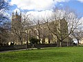 | 640 × 473 (126 KB) | GeographBot | == {{int:filedesc}} == {{Information |description={{en|1=St Martin's Church, Brighouse This church was first built in 1831-2, and had seating for 1100 people. Part of the cost was met by the government under the 'Million Act', which provided for the erect |
File usage
The following pages on the English Wikipedia use this file (pages on other projects are not listed):
Global file usage
The following other wikis use this file:
- Usage on azb.wikipedia.org