
File:St. Paul's church, Rusthall - geograph.org.uk - 807503.jpg

No higher resolution available.
St._Paul's_church,_Rusthall_-_geograph.org.uk_-_807503.jpg (545 × 455 pixels, file size: 259 KB, MIME type: image/jpeg)
| This is a file from the Wikimedia Commons. Information from its description page there is shown below. Commons is a freely licensed media file repository. You can help. |
Summary
| Description |
English: St. Paul's church, Rusthall Built in the 1850's and further extended subsequently to accommodate the expanding population of the west side of Tunbridge wells. |
| Date | |
| Source | From geograph.org.uk |
| Author | Jonathan Billinger |
| Attribution (required by the license) | Jonathan Billinger / St. Paul's church, Rusthall / |
| Camera location | | View this and other nearby images on: OpenStreetMap |
|---|
| Object location | | View this and other nearby images on: OpenStreetMap |
|---|
Licensing

|
This image was taken from the Geograph project collection. See this photograph's page on the Geograph website for the photographer's contact details. The copyright on this image is owned by Jonathan Billinger and is licensed for reuse under the Creative Commons Attribution-ShareAlike 2.0 license.
|
This file is licensed under the Creative Commons Attribution-Share Alike 2.0 Generic license.
Attribution: Jonathan Billinger
- You are free:
- to share – to copy, distribute and transmit the work
- to remix – to adapt the work
- Under the following conditions:
- attribution – You must give appropriate credit, provide a link to the license, and indicate if changes were made. You may do so in any reasonable manner, but not in any way that suggests the licensor endorses you or your use.
- share alike – If you remix, transform, or build upon the material, you must distribute your contributions under the same or compatible license as the original.
File history
Click on a date/time to view the file as it appeared at that time.
| Date/Time | Thumbnail | Dimensions | User | Comment | |
|---|---|---|---|---|---|
| current | 13:45, 13 January 2016 | 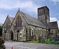 | 545 × 455 (259 KB) | Centpacrr | Tweaks |
| 13:11, 13 January 2016 |  | 545 × 455 (258 KB) | Centpacrr | Remove tree as requested, crop | |
| 09:37, 20 February 2011 | 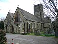 | 640 × 480 (94 KB) | GeographBot | == {{int:filedesc}} == {{Information |description={{en|1=St. Paul's church, Rusthall Built in the 1850's and further extended subsequently to accommodate the expanding population of the west side of Tunbridge wells.}} |date=2008-04-17 |source=From [http:/ |
File usage
The following pages on the English Wikipedia use this file (pages on other projects are not listed):
Global file usage
The following other wikis use this file:
- Usage on www.wikidata.org