
File:Sputnik Planitia elevation map.png

Size of this preview: 544 × 600 pixels. Other resolutions: 218 × 240 pixels | 435 × 480 pixels | 722 × 796 pixels.
Original file (722 × 796 pixels, file size: 337 KB, MIME type: image/png)
| This is a file from the Wikimedia Commons. Information from its description page there is shown below. Commons is a freely licensed media file repository. You can help. |
Summary
| Description |
English: A topographic image of the Sputnik Planitia basin, showing the rising scarps bordering the glacial plains. The banding is an artefact of the camera. |
| Date | |
| Source | Geological mapping of Sputnik Planitia on Pluto, Icarus (2017), doi: 10.1016/j.icarus.2017.01.011 |
| Author | Oliver L. White, Jeffrey M. Moore, William B. McKinnon, John R. Spencer, Alan D. Howard, Paul M. Schenk, Ross A. Beyer, Francis Nimmo, Kelsi N. Singer, Orkan M. Umurhan, S. Alan Stern, Kimberly Ennico, Cathy B. Olkin, Harold A. Weaver, Leslie A. Young, Andrew F. Cheng, Tanguy Bertrand, Richard P. Binzel, Alissa M. Earle, Will M. Grundy, Tod R. Lauer, Silvia Protopapa, Stuart J. Robbins, Bernard Schmitt, the New Horizons Science Team |
Licensing
| This file is in the public domain in the United States because it was solely created by NASA. NASA copyright policy states that "NASA material is not protected by copyright unless noted". (See Template:PD-USGov, NASA copyright policy page or JPL Image Use Policy.) | ||
 |
Warnings:
|
File history
Click on a date/time to view the file as it appeared at that time.
| Date/Time | Thumbnail | Dimensions | User | Comment | |
|---|---|---|---|---|---|
| current | 02:26, 11 May 2017 | 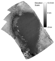 | 722 × 796 (337 KB) | Renerpho | User created page with UploadWizard |
File usage
The following pages on the English Wikipedia use this file (pages on other projects are not listed):
Global file usage
The following other wikis use this file:
- Usage on fr.wikipedia.org