
File:Spratly Islands relief location map.svg
Size of this PNG preview of this SVG file: 671 × 599 pixels. Other resolutions: 269 × 240 pixels | 538 × 480 pixels | 860 × 768 pixels | 1,147 × 1,024 pixels | 2,293 × 2,048 pixels | 720 × 643 pixels.
Original file (SVG file, nominally 720 × 643 pixels, file size: 2.23 MB)
| This is a file from the Wikimedia Commons. Information from its description page there is shown below. Commons is a freely licensed media file repository. You can help. |
Summary
| Description |
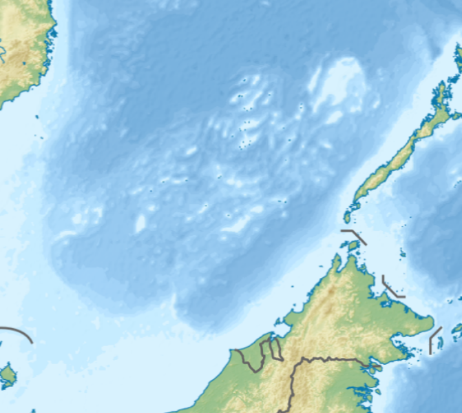
English: Location map of the Spratly Islands relief
N-S stretching 102.0004% in SVG file. Geographic limits of the map:
|
| Date | |
| Source | Own work |
| Author | LuciferAhriman |
| Other versions |
|

Licensing
I, the copyright holder of this work, hereby publish it under the following license:
This file is licensed under the Creative Commons Attribution-Share Alike 4.0 International license.
- You are free:
- to share – to copy, distribute and transmit the work
- to remix – to adapt the work
- Under the following conditions:
- attribution – You must give appropriate credit, provide a link to the license, and indicate if changes were made. You may do so in any reasonable manner, but not in any way that suggests the licensor endorses you or your use.
- share alike – If you remix, transform, or build upon the material, you must distribute your contributions under the same or compatible license as the original.
File history
Click on a date/time to view the file as it appeared at that time.
| Date/Time | Thumbnail | Dimensions | User | Comment | |
|---|---|---|---|---|---|
| current | 08:47, 17 October 2020 |  | 720 × 643 (2.23 MB) | LuciferAhriman | Uploaded own work with UploadWizard |
File usage
The following pages on the English Wikipedia use this file (pages on other projects are not listed):
- Alison Reef
- Amboyna Cay
- Ardasier Reef
- Barque Canada Reef
- Bombay Castle (South China Sea)
- Central London Reef
- Collins Reef
- Commodore Reef
- Cornwallis South Reef
- Cuarteron Reef
- Dallas Reef
- Discovery Great Reef
- East London Reef
- Eldad Reef
- Erica Reef
- Fiery Cross Reef
- First Thomas Shoal
- Flat Island (South China Sea)
- Gaven Reefs
- Grierson Reef
- Half Moon Shoal
- Hughes Reef
- Investigator Shoal
- Irving Reef
- James Shoal
- Johnson South Reef
- Ladd Reef
- Lankiam Cay
- Lansdowne Reef
- Loaita Cay
- Loaita Island
- Loaita Nan
- Louisa Reef
- Mariveles Reef
- Mischief Reef
- Namyit Island
- Nanshan Island
- North Danger Reef
- Northeast Cay
- Northeast Investigator Shoal
- Pearson Reef
- Petley Reef
- Royal Captain Shoal
- Sabina Shoal
- Sand Cay
- Second Thomas Shoal
- Sin Cowe Island
- South Reef
- Southwest Cay
- Spratly Island
- Subi Reef
- Swallow Reef
- Taiping Island
- Tennent Reef
- Third Thomas Shoal
- Thitu Island
- West London Reef
- West York Island
- Western Reef
- Zhongzhou Reef
- Module:Location map/data/Spratly Islands relief
- Module:Location map/data/Spratly Islands relief/doc
Global file usage
The following other wikis use this file:
- Usage on bcl.wikipedia.org
- Usage on fr.wikipedia.org
- Usage on ms.wikipedia.org
- Usage on si.wikipedia.org
- Usage on uk.wikipedia.org
- Usage on uz.wikipedia.org
- Usage on zh.wikipedia.org