
File:Southern Tyrol 1804.jpg
Size of this preview: 715 × 599 pixels. Other resolutions: 286 × 240 pixels | 573 × 480 pixels | 916 × 768 pixels | 1,221 × 1,024 pixels | 1,789 × 1,500 pixels.
Original file (1,789 × 1,500 pixels, file size: 819 KB, MIME type: image/jpeg)
| This is a file from the Wikimedia Commons. Information from its description page there is shown below. Commons is a freely licensed media file repository. You can help. |
Summary
| Description |
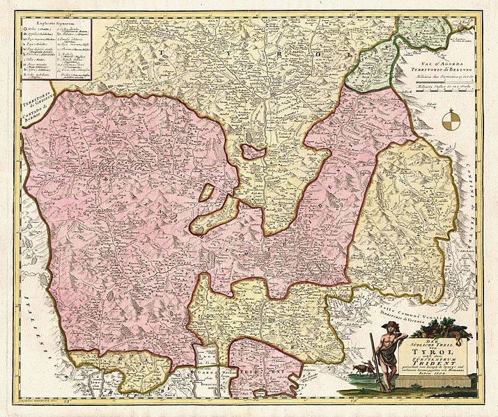
English: Map from 1804 showing the southern section of Tyrol with the newly-created Principality of Trent ("Fürstentum Trident", in purple). The Prince-Bishopric of Trent had been secularized in 1803 and erected into a secular principality. It was owned by Austria, then Bavaria and finally Austria again. Based on a 1762 map by Joseph von Sperges. Printed by Homann Heirs (Homann Erben). |
| Date | |
| Source | www.vialibri.com, rare and out of print books |
| Author | Homann Heirs, 1804 |
Licensing
|
This work is in the public domain in its country of origin and other countries and areas where the copyright term is the author's life plus 100 years or fewer. | |
| This file has been identified as being free of known restrictions under copyright law, including all related and neighboring rights. | |
File history
Click on a date/time to view the file as it appeared at that time.
| Date/Time | Thumbnail | Dimensions | User | Comment | |
|---|---|---|---|---|---|
| current | 02:44, 22 December 2015 |  | 1,789 × 1,500 (819 KB) | Lubiesque | User created page with UploadWizard |
File usage
The following pages on the English Wikipedia use this file (pages on other projects are not listed):
Global file usage
The following other wikis use this file:
- Usage on zh.wikipedia.org