
File:Southerham Grey Pit - geograph.org.uk - 761782.jpg

No higher resolution available.
Southerham_Grey_Pit_-_geograph.org.uk_-_761782.jpg (640 × 479 pixels, file size: 84 KB, MIME type: image/jpeg)
| This is a file from the Wikimedia Commons. Information from its description page there is shown below. Commons is a freely licensed media file repository. You can help. |
Summary
| Description |
English: Southerham Grey Pit Quarry that until relatively recently produced grey chalk and is the only inland bed of this nature. In addition it is highly valued for the number of fossils found in its layers particularly those of marine life. The famous geologist and palaeontologist Gideon Mantell spent his childhood years searching the quarry and other nearby for ammonites. Since quarrying ceased the pit has been used for storage being the final destination for the trolley buses of Brighton before being scrapped and more recently refrigerators. Taken from the eastern bank of the Ouse with Southerham Junction in the foreground where the line to Seaford leaves the one to Eastbourne and Hastings. |
| Date | |
| Source | From geograph.org.uk |
| Author | Simon Carey |
| Attribution (required by the license) | Simon Carey / Southerham Grey Pit / |
| Camera location | | View this and other nearby images on: OpenStreetMap |
|---|
| Object location | | View this and other nearby images on: OpenStreetMap |
|---|
Licensing

|
This image was taken from the Geograph project collection. See this photograph's page on the Geograph website for the photographer's contact details. The copyright on this image is owned by Simon Carey and is licensed for reuse under the Creative Commons Attribution-ShareAlike 2.0 license.
|
This file is licensed under the Creative Commons Attribution-Share Alike 2.0 Generic license.
Attribution: Simon Carey
- You are free:
- to share – to copy, distribute and transmit the work
- to remix – to adapt the work
- Under the following conditions:
- attribution – You must give appropriate credit, provide a link to the license, and indicate if changes were made. You may do so in any reasonable manner, but not in any way that suggests the licensor endorses you or your use.
- share alike – If you remix, transform, or build upon the material, you must distribute your contributions under the same or compatible license as the original.
File history
Click on a date/time to view the file as it appeared at that time.
| Date/Time | Thumbnail | Dimensions | User | Comment | |
|---|---|---|---|---|---|
| current | 19:35, 19 February 2011 | 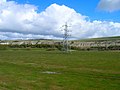 | 640 × 479 (84 KB) | GeographBot | == {{int:filedesc}} == {{Information |description={{en|1=Southerham Grey Pit Quarry that until relatively recently produced grey chalk and is the only inland bed of this nature. In addition it is highly valued for the number of fossils found in its layers |
File usage
The following pages on the English Wikipedia use this file (pages on other projects are not listed):
Global file usage
The following other wikis use this file:
- Usage on fr.wikipedia.org
- Usage on ru.wikipedia.org
- Usage on www.wikidata.org