
File:South Tyneside Electric train at Newcastle Central, 1938, geograph-4869768-by-Walter-Dendy,-deceased.jpg

Size of this preview: 800 × 497 pixels. Other resolutions: 320 × 199 pixels | 640 × 397 pixels | 1,024 × 636 pixels | 1,280 × 794 pixels | 2,130 × 1,322 pixels.
Original file (2,130 × 1,322 pixels, file size: 1.34 MB, MIME type: image/jpeg)
| This is a file from the Wikimedia Commons. Information from its description page there is shown below. Commons is a freely licensed media file repository. You can help. |
| Description |
English: South Tyneside Electric train at Newcastle Central, 1938 View NE at the west end of Central Station, Platform 11: a train for South Shields waits, made up of ex-NER/LNER third-rail electric (600v) reconditioned stock (after fire damage), which worked on the North Tyneside lines before the South Tyneside line was electrified in 1938 - shortly before this photograph. Glimpsed on the left is the cab-side of No. 4482 'Golden Eagle', one of the then new Gresley A4 Streamliners. |
||
| Date | |||
| Source | geograph.org.uk | ||
| Author | Walter Dendy, deceased | ||
| Permission (Reusing this file) |
This file is licensed under the Creative Commons Attribution-Share Alike 2.0 Generic license. Attribution: Walter Dendy, deceased
|
||
| Attribution (required by the license) | Walter Dendy, deceased / South Tyneside Electric train at Newcastle Central, 1938 / | ||

| Camera location | | View this and other nearby images on: OpenStreetMap |
|---|
| Object location | | View this and other nearby images on: OpenStreetMap |
|---|
File history
Click on a date/time to view the file as it appeared at that time.
| Date/Time | Thumbnail | Dimensions | User | Comment | |
|---|---|---|---|---|---|
| current | 17:02, 7 April 2016 | 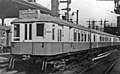 | 2,130 × 1,322 (1.34 MB) | G-13114 | Larger version |
| 16:59, 7 April 2016 |  | 1,024 × 636 (131 KB) | G-13114 | {{Information |description={{en|1=South Tyneside Electric train at Newcastle Central, 1938 View NE at the west end of Central Station, Platform 11: a train for South Shields waits, made up of ex-NER/LNER third-rail electric (600v) reconditioned stock... |
File usage
The following pages on the English Wikipedia use this file (pages on other projects are not listed):
Global file usage
The following other wikis use this file:
- Usage on ja.wikipedia.org