
File:Somerset House, Strand.jpg
No higher resolution available.
Somerset_House,_Strand.jpg (640 × 506 pixels, file size: 235 KB, MIME type: image/jpeg)
| This is a file from the Wikimedia Commons. Information from its description page there is shown below. Commons is a freely licensed media file repository. You can help. |
Summary
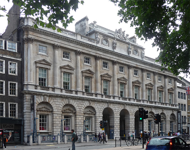
| Description |
English: A particularly noble and dignified facade, as befitting the academic style of its architect, Sir William Chambers, then "Comptroller of the Office of Works". Somerset House was the civil service's first office block. Built 1776-80. Ground floor of windows set into a rusticated arcade, the three central arches providing access to the courtyard and buildings behind. Then a straight sequence of windows between attached Corinthian columns. The central three bays are crowned by an attic with carved figures, oval windows and swags. All very Roman. Grade I listed.
It is now largely an arts and cultural centre. In winter, the courtyard, formerly the taxmen's car park, is turned into a popular ice rink. |
| Date | |
| Source | https://www.geograph.org.uk/photo/2778345 |
| Author | Stephen Richards |
| Camera location | | View this and other nearby images on: OpenStreetMap |
|---|
| Object location | | View this and other nearby images on: OpenStreetMap |
|---|
Licensing

|
This image was taken from the Geograph project collection. See this photograph's page on the Geograph website for the photographer's contact details. The copyright on this image is owned by Stephen Richards and is licensed for reuse under the Creative Commons Attribution-ShareAlike 2.0 license.
|
This file is licensed under the Creative Commons Attribution-Share Alike 2.0 Generic license.
Attribution: Stephen Richards
- You are free:
- to share – to copy, distribute and transmit the work
- to remix – to adapt the work
- Under the following conditions:
- attribution – You must give appropriate credit, provide a link to the license, and indicate if changes were made. You may do so in any reasonable manner, but not in any way that suggests the licensor endorses you or your use.
- share alike – If you remix, transform, or build upon the material, you must distribute your contributions under the same or compatible license as the original.
File history
Click on a date/time to view the file as it appeared at that time.
| Date/Time | Thumbnail | Dimensions | User | Comment | |
|---|---|---|---|---|---|
| current | 05:44, 3 June 2012 |  | 640 × 506 (235 KB) | Ham II |
File usage
The following pages on the English Wikipedia use this file (pages on other projects are not listed):
- Courtauld Gallery
- Courtauld Institute of Art
- Grade I listed buildings in the City of Westminster
- List of museums in London
- Member institutions of the University of London
- Somerset House
- University of London
- William Chambers (architect)
- User:Chickstarr404/Gather lists
- User:Chickstarr404/Gather lists/18948 – "Anthony Blunt: His Lives" by Miranda Carter
Global file usage
The following other wikis use this file:
- Usage on arz.wikipedia.org
- Usage on az.wikipedia.org
- Usage on be.wikipedia.org
- Usage on bg.wikipedia.org
- Usage on ca.wikipedia.org
- Usage on cs.wikipedia.org
- Usage on cy.wikipedia.org
- Usage on dag.wikipedia.org
- Usage on de.wikipedia.org
- Usage on de.wikivoyage.org
- Usage on el.wikipedia.org
- Usage on en.wikivoyage.org
- Usage on eo.wikipedia.org
- Usage on es.wikipedia.org
- Usage on eu.wikipedia.org
- Usage on fa.wikipedia.org
- Usage on fi.wikipedia.org
- Usage on fr.wikipedia.org
- Usage on fr.wikivoyage.org
- Usage on ga.wikipedia.org
- Usage on he.wikipedia.org
- Usage on he.wikivoyage.org
- Usage on hy.wikipedia.org
- Usage on id.wikipedia.org
- Usage on it.wikipedia.org
- Usage on it.wikivoyage.org
- Usage on ja.wikipedia.org
- Usage on lt.wikipedia.org
- Usage on ml.wikipedia.org
- Usage on no.wikipedia.org
- Usage on pt.wikipedia.org
- Usage on ru.wikipedia.org
- Usage on sv.wikipedia.org
View more global usage of this file.