
File:Six Day War Territories.svg

Size of this PNG preview of this SVG file: 400 × 600 pixels. Other resolutions: 160 × 240 pixels | 320 × 480 pixels | 512 × 768 pixels | 682 × 1,024 pixels | 1,365 × 2,048 pixels.
Original file (SVG file, nominally 800 × 1,200 pixels, file size: 61 KB)
| This is a file from the Wikimedia Commons. Information from its description page there is shown below. Commons is a freely licensed media file repository. You can help. |
Summary
| Description |
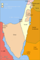
English: Israel and the territories Israel occupied in the Six day war.
Deutsch: Israel (gelb) und die im Sechstagekrieg eroberten und besetzten Gebiete (hell-ockerfarben).
العربية: خريطة إسرائيل والدول العربية المجاورة بعد حرب الأيام الستة، والتي تسمى عند الإعلام العربي حرب النكسة، وذلك بتاريخ 6 يونيو 1967م، حيث أكتسبت جيش الدفاع الإسرائيلي الحرب للإستيلاء على الأراضي الفلسطينية (الضفة الغربية والقدس الشرقية وقطاع غزة) وضم الجولان للسيادة الإسرائيلية وتحويل شبه جزيرة سيناء المصرية وجزيرتي تيران وصنافير إلى منطقة عسكرية. |
| Date | |
| Source | |
| Author |
|
| Other versions |
=[]
|


| This SVG file contains embedded text that can be translated into your language, using any capable SVG editor, text editor or the SVG Translate tool. For more information see: About translating SVG files. |
This W3C-unspecified vector image was created with Inkscape .
Licensing
I, the copyright holder of this work, hereby publish it under the following license:
This file is licensed under the Creative Commons Attribution-Share Alike 3.0 Unported license.
- You are free:
- to share – to copy, distribute and transmit the work
- to remix – to adapt the work
- Under the following conditions:
- attribution – You must give appropriate credit, provide a link to the license, and indicate if changes were made. You may do so in any reasonable manner, but not in any way that suggests the licensor endorses you or your use.
- share alike – If you remix, transform, or build upon the material, you must distribute your contributions under the same or compatible license as the original.
File history
Click on a date/time to view the file as it appeared at that time.
| Date/Time | Thumbnail | Dimensions | User | Comment | |
|---|---|---|---|---|---|
| current | 05:39, 6 April 2024 |  | 800 × 1,200 (61 KB) | Tahmid | File uploaded using svgtranslate tool (https://svgtranslate.toolforge.org/). Added translation for bn. |
| 12:00, 12 February 2024 |  | 800 × 1,200 (52 KB) | Andrei Stroe | File uploaded using svgtranslate tool (https://svgtranslate.toolforge.org/). Added translation for ro. | |
| 14:36, 23 October 2023 | 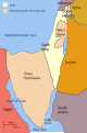 | 800 × 1,200 (42 KB) | Elli | Reverted to version as of 16:59, 25 December 2012 (UTC) these translations appear to have broken English rendering | |
| 04:25, 18 May 2021 |  | 800 × 1,200 (60 KB) | Hilal knight | File uploaded using svgtranslate tool (https://svgtranslate.toolforge.org/). Added translation for az-latn. | |
| 04:22, 18 May 2021 | 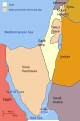 | 800 × 1,200 (52 KB) | Hilal knight | File uploaded using svgtranslate tool (https://svgtranslate.toolforge.org/). Added translation for az-latn. | |
| 04:14, 18 May 2021 |  | 800 × 1,200 (52 KB) | Hilal knight | File uploaded using svgtranslate tool (https://svgtranslate.toolforge.org/). Added translation for az-latn. | |
| 16:59, 25 December 2012 | 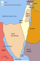 | 800 × 1,200 (42 KB) | AnonMoos | unfortunately, the word "Heights" was misspelled | |
| 21:37, 6 October 2011 |  | 800 × 1,200 (43 KB) | Kathovo |
File usage
The following pages on the English Wikipedia use this file (pages on other projects are not listed):
Global file usage
The following other wikis use this file:
- Usage on als.wikipedia.org
- Usage on ar.wikipedia.org
- Usage on arz.wikipedia.org
- Usage on azb.wikipedia.org
- Usage on az.wikipedia.org
- Altıgünlük müharibə
- Ərəb-İsrail müharibələri
- Vikipediya:Həftənin seçilmiş məqaləsi/may 2019
- Vikipediya:Həftənin seçilmiş məqaləsi/19. Həftə 2019
- Vikipediya:Həftənin seçilmiş məqaləsi/may 2020
- Vikipediya:Həftənin seçilmiş məqaləsi/19. Həftə 2020
- Vikipediya:Həftənin seçilmiş məqaləsi/may 2021
- Vikipediya:Həftənin seçilmiş məqaləsi/20. Həftə 2021
- Usage on bg.wikipedia.org
- Usage on bn.wikipedia.org
- Usage on br.wikipedia.org
- Usage on ca.wikipedia.org
- Usage on cs.wikipedia.org
- Usage on de.wikipedia.org
- Usage on el.wikipedia.org
- Usage on fa.wikipedia.org
- Usage on he.wikipedia.org
- Usage on hi.wikipedia.org
- Usage on hy.wikipedia.org
- Usage on id.wikipedia.org
- Usage on it.wikipedia.org
- Usage on ja.wikipedia.org
- Usage on kn.wikipedia.org
- Usage on ko.wikipedia.org
- Usage on lb.wikipedia.org
- Usage on mk.wikipedia.org
- Usage on ml.wikipedia.org
- Usage on mr.wikipedia.org
- Usage on ms.wikipedia.org
- Usage on ne.wikipedia.org
- Usage on nl.wikipedia.org
- Usage on nn.wikipedia.org
- Usage on pa.wikipedia.org
- Usage on pnb.wikipedia.org
- Usage on ro.wikipedia.org
- Usage on sat.wikipedia.org
View more global usage of this file.