File:Santo Stefano (Venice) Campaniles.jpg

Page contents not supported in other languages.
This is a file from the Wikimedia Commons
From Wikipedia, the free encyclopedia

Original file(6,416 × 4,912 pixels, file size: 17.13 MB, MIME type: image/jpeg)

Summary

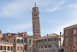
Lleaning campanile, and campanile a vela of church Santo Stefano in Venice

VI seal

This image has been assessed under the valued image criteria and is considered the most valued image on Commons within the scope: Leaning campanile, and campanile a vela of church Santo Stefano in Venice.. You can see its nomination here.

Description
English: Leaning campanile, and campanile a vela of church Santo Stefano in Venice, seen from the Campo Santo Stefano.
Français : Le campanile penché et le campanile a vela de Santo Stefano à Venise, vu du Campo Santo Stefano.
Italiano: Il campanile pendente, e il campanile a vela della Chiesa di Santo Stefano, Venezia, visto dal campo Santo Stefano.
Date Taken on 12 May 2014
Source Own work
Author Didier Descouens
Permission
(Reusing this file)
This file is copyrighted and has been released under a license which is incompatible with Facebook's licensing terms. It is not permitted to upload this file at Facebook.
I, the copyright holder of this work, hereby publish it under the following license:
w:en:Creative Commons
attribution share alike
This file is licensed under the Creative Commons Attribution-Share Alike 4.0 International license.
You are free:
  • to share – to copy, distribute and transmit the work
  • to remix – to adapt the work
Under the following conditions:
  • attribution – You must give appropriate credit, provide a link to the license, and indicate if changes were made. You may do so in any reasonable manner, but not in any way that suggests the licensor endorses you or your use.
  • share alike – If you remix, transform, or build upon the material, you must distribute your contributions under the same or compatible license as the original.
Other versions
Object location45° 26′ 00.47″ N, 12° 19′ 51.57″ E Kartographer map based on OpenStreetMap.View this and other nearby images on: OpenStreetMapinfo

Captions

Add a one-line explanation of what this file represents

12 May 2014

45°26'0.467"N, 12°19'51.571"E

File history

Click on a date/time to view the file as it appeared at that time.

Date/TimeThumbnailDimensionsUserComment
current15:05, 3 September 2014Thumbnail for version as of 15:05, 3 September 20146,416 × 4,912 (17.13 MB)Archaeodontosaurus{{Information |Description ={{en|1=c}} |Source ={{own}} |Author =Archaeodontosaurus |Date = |Permission = |other_versions = }}
The following pages on the English Wikipedia use this file (pages on other projects are not listed):

Global file usage

The following other wikis use this file:

Metadata