
File:Santa Monica Bay Map.jpg
No higher resolution available.
Santa_Monica_Bay_Map.jpg (468 × 597 pixels, file size: 283 KB, MIME type: image/jpeg)
| This is a file from the Wikimedia Commons. Information from its description page there is shown below. Commons is a freely licensed media file repository. You can help. |
Summary
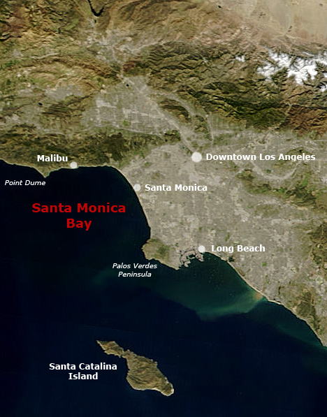
English: Satellite pictures of Southern California with Santa Monica Bay and Greater Los Angeles.
- Following the original text out of the English wikipedia, where it was originally uploaded:
- Map of Southern California with Santa Monica Bay identified
- Underlying map is an aerial map obtained from NASA (original:
- The labeling is by en:User:Mikeetc
Licensing
| This file is in the public domain in the United States because it was solely created by NASA. NASA copyright policy states that "NASA material is not protected by copyright unless noted". (See Template:PD-USGov, NASA copyright policy page or JPL Image Use Policy.) | ||
 |
Warnings:
|
File history
Click on a date/time to view the file as it appeared at that time.
| Date/Time | Thumbnail | Dimensions | User | Comment | |
|---|---|---|---|---|---|
| current | 23:55, 28 May 2006 |  | 468 × 597 (283 KB) | Otto Normalverbraucher | following the original text out of the english wikipedia, where it was originally uploaded: ''Map of Southern California with Santa Monica Bay identified Underlying map is an aerial map obtained from NASA (original: http://earthobservatory.nasa.gov/Natu |
File usage
The following pages on the English Wikipedia use this file (pages on other projects are not listed):
Global file usage
The following other wikis use this file:
- Usage on ar.wikipedia.org
- Usage on ceb.wikipedia.org
- Usage on ckb.wikipedia.org
- Usage on de.wikipedia.org
- Usage on es.wikipedia.org
- Usage on fr.wikipedia.org
- Usage on fr.wikibooks.org
- Usage on he.wikipedia.org
- Usage on pl.wikipedia.org
- Usage on pt.wikipedia.org
- Usage on ro.wikipedia.org
- Usage on ru.wikipedia.org
- Usage on www.wikidata.org