
File:Sandy 2012-10-29 1820Z.jpg
Size of this preview: 459 × 599 pixels. Other resolutions: 184 × 240 pixels | 368 × 480 pixels | 588 × 768 pixels | 784 × 1,024 pixels | 1,569 × 2,048 pixels | 7,200 × 9,400 pixels.
Original file (7,200 × 9,400 pixels, file size: 12.94 MB, MIME type: image/jpeg)
| This is a file from the Wikimedia Commons. Information from its description page there is shown below. Commons is a freely licensed media file repository. You can help. |
| Warning | The original file is very high-resolution. It might not load properly or could cause your browser to freeze when opened at full size. |
|---|
Summary
| Description |
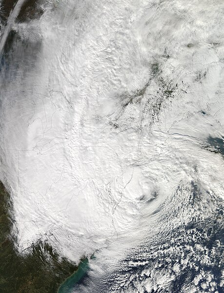
English: Satellite image of Hurricane Sandy from the Moderate Resolution Imaging Spectroradiometer (MODIS) on NASA’s Aqua satellite taken at 2:20 p.m. EDT (18:20 UTC) on October 29, 2012.
At 2:00 p.m. EDT, the National Hurricane Center reported that the storm was located at 38.3°N, 73.1°W, about 110 mi (180 km) southeast of Atlantic City, MJ, and 175 mi (285 km) south-southeast of New York City. Maximum sustained winds were 90 mph (150 km/h), and the central minimum pressure was 940 mbar(27.76 inHg). |
| Date | |
| Source | http://earthobservatory.nasa.gov/ (Losslessly converted from progressive to baseline mode to allow thumbnail creation on Commons). |
| Author | NASA |
Licensing
| This file is in the public domain in the United States because it was solely created by NASA. NASA copyright policy states that "NASA material is not protected by copyright unless noted". (See Template:PD-USGov, NASA copyright policy page or JPL Image Use Policy.) | ||
 |
Warnings:
|
File history
Click on a date/time to view the file as it appeared at that time.
| Date/Time | Thumbnail | Dimensions | User | Comment | |
|---|---|---|---|---|---|
| current | 12:57, 16 January 2013 |  | 7,200 × 9,400 (12.94 MB) | Moogsi | |
| 07:49, 16 January 2013 |  | 7,200 × 9,400 (12.69 MB) | Inks.LWC | Try this again | |
| 07:44, 16 January 2013 |  | 7,200 × 9,400 (12.69 MB) | Inks.LWC | {{Information |Description ={{en|1=Satellite image of Hurricane Sandy from the Moderate Resolution Imaging Spectroradiometer (MODIS) on NASA’s Aqua satellite taken at 2:20 p.m. EDT (18:20 UTC) on October 29, 2012. At 2:00 p.m. EDT, the National H... |
File usage
The following pages on the English Wikipedia use this file (pages on other projects are not listed):