
File:SaintVincentBrewerySite.jpg

Size of this preview: 800 × 533 pixels. Other resolutions: 320 × 213 pixels | 640 × 427 pixels.
Original file (900 × 600 pixels, file size: 137 KB, MIME type: image/jpeg)
| This is a file from the Wikimedia Commons. Information from its description page there is shown below. Commons is a freely licensed media file repository. You can help. |
Summary
| Description |
English: The ruins of the site of the brewery that made Saint Vincent Beer in a 1982 National High Altitude Photography color image. |
||
| Date | |||
| Source | Own work | ||
| Creator | |||
| Permission (Reusing this file) |
|
||
| Georeferencing | If inappropriate please set warp_status = skip to hide. | ||
| JPG development | This map was created with ArcGIS Pro. |
Licensing
Data
This image is in the public domain in the United States because it only contains materials that originally came from the United States Geological Survey, an agency of the United States Department of the Interior. For more information, see the official USGS copyright policy.
|
Final Map
I, the copyright holder of this work, hereby publish it under the following license:
| This file is made available under the Creative Commons CC0 1.0 Universal Public Domain Dedication. | |
| The person who associated a work with this deed has dedicated the work to the public domain by waiving all of their rights to the work worldwide under copyright law, including all related and neighboring rights, to the extent allowed by law. You can copy, modify, distribute and perform the work, even for commercial purposes, all without asking permission.
|
File history
Click on a date/time to view the file as it appeared at that time.
| Date/Time | Thumbnail | Dimensions | User | Comment | |
|---|---|---|---|---|---|
| current | 13:25, 15 January 2022 | 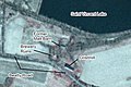 | 900 × 600 (137 KB) | Guerillero | {{User:Guerillero/Template |Description= {{en|The ruins of the site of the brewery that made Saint Vincent Beer] in a 1982 [https://www.usgs.gov/centers/eros/science/usgs-eros-archive-aerial-photography-national-high-altitude-photography-nhap National High Altitude Photography] color image.}} |Source={{own}} |Date= 15 January 2022 }} == {{int:license-header}} == ===Data=== {{PD-USGov-USGS}} ===Final Map=== {{self|cc-by-sa-4.0}} [[Category:Saint Vincent Arch... |
File usage
The following pages on the English Wikipedia use this file (pages on other projects are not listed):