
File:Russian Occupation of Kharkiv Oblast.svg

Original file (SVG file, nominally 1,236 × 1,134 pixels, file size: 234 KB)
| This is a file from the Wikimedia Commons. Information from its description page there is shown below. Commons is a freely licensed media file repository. You can help. |
Summary

|
This file may be updated to reflect new information. If you wish to use a specific version of the file without new updates being mirrored, please upload the required version as a separate file. |
| Description |
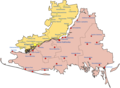
English: Map showing the various zones of Russian Occupation in Kharkiv Oblast
|
| Date | |
| Source |
Own work, derivate of 2022 Russian invasion of Ukraine.svg by Viewsridge
|
| Author | Physeters |
| Other versions |
[]
|


This file is translated using SVG <switch> elements. All translations are stored in the same file! Learn more.
For most Wikipedia projects, you can embed the file normally (without a To translate the text into your language, you can use the SVG Translate tool. Alternatively, you can download the file to your computer, add your translations using whatever software you're familiar with, and re-upload it with the same name. You will find help in Graphics Lab if you're not sure how to do this. |
Licensing
- You are free:
- to share – to copy, distribute and transmit the work
- to remix – to adapt the work
- Under the following conditions:
- attribution – You must give appropriate credit, provide a link to the license, and indicate if changes were made. You may do so in any reasonable manner, but not in any way that suggests the licensor endorses you or your use.
- share alike – If you remix, transform, or build upon the material, you must distribute your contributions under the same or compatible license as the original.
File history
Click on a date/time to view the file as it appeared at that time.
| Date/Time | Thumbnail | Dimensions | User | Comment | |
|---|---|---|---|---|---|
| current | 07:05, 29 February 2024 |  | 1,236 × 1,134 (234 KB) | Physeters | Small update per the ISW |
| 07:26, 15 February 2024 |  | 1,236 × 1,134 (234 KB) | Physeters | small update per the ISW | |
| 21:10, 5 February 2024 |  | 1,236 × 1,134 (233 KB) | Physeters | Updates per the ISW; add Synkivka, Tavilzhanka, Kyslivka and Dvorichna | |
| 17:01, 23 April 2023 |  | 1,236 × 1,134 (234 KB) | Nahabino | Update per ISW | |
| 19:10, 20 February 2023 |  | 1,236 × 1,134 (227 KB) | Physeters | Updates per the ISW | |
| 00:42, 7 December 2022 |  | 1,236 × 1,134 (234 KB) | Nahabino | Update per ISW | |
| 22:16, 25 November 2022 |  | 1,236 × 1,134 (234 KB) | Nahabino | Update per ISW | |
| 23:05, 20 November 2022 |  | 1,236 × 1,134 (234 KB) | Nahabino | Update per ISW | |
| 22:30, 12 November 2022 |  | 1,236 × 1,134 (234 KB) | Nahabino | Update per ISW | |
| 00:30, 10 November 2022 |  | 1,236 × 1,134 (227 KB) | Physeters | remove small Russian controlled area near Kozacha Lopan |
File usage
Global file usage
The following other wikis use this file:
- Usage on ca.wikipedia.org
- Usage on fr.wikipedia.org
- Usage on id.wikipedia.org
- Usage on ja.wikipedia.org
- Usage on lv.wikipedia.org
- Usage on uk.wikipedia.org
- Usage on zh.wikipedia.org