
File:Rouen track layout 1955-1971.gif

Size of this preview: 800 × 473 pixels. Other resolutions: 320 × 189 pixels | 640 × 378 pixels | 860 × 508 pixels.
Original file (860 × 508 pixels, file size: 14 KB, MIME type: image/gif)
| This is a file from the Wikimedia Commons. Information from its description page there is shown below. Commons is a freely licensed media file repository. You can help. |
Summary
| Description |
English: Circuit de Rouen-les-Essarts track layout from 1955 to 1971.
Italiano: Mappa del tracciato del Circuito di Rouen-les-Essarts dal 1955 al 1971 |
||
| Date | |||
| Source | Own work | ||
| Author | Micap | ||
| Other versions |
|

Licensing
I, the copyright holder of this work, hereby publish it under the following licenses:
This file is licensed under the Creative Commons Attribution-Share Alike 3.0 Unported license.
- You are free:
- to share – to copy, distribute and transmit the work
- to remix – to adapt the work
- Under the following conditions:
- attribution – You must give appropriate credit, provide a link to the license, and indicate if changes were made. You may do so in any reasonable manner, but not in any way that suggests the licensor endorses you or your use.
- share alike – If you remix, transform, or build upon the material, you must distribute your contributions under the same or compatible license as the original.

|
Permission is granted to copy, distribute and/or modify this document under the terms of the GNU Free Documentation License, Version 1.2 or any later version published by the Free Software Foundation; with no Invariant Sections, no Front-Cover Texts, and no Back-Cover Texts. A copy of the license is included in the section entitled GNU Free Documentation License. |
You may select the license of your choice.
File history
Click on a date/time to view the file as it appeared at that time.
| Date/Time | Thumbnail | Dimensions | User | Comment | |
|---|---|---|---|---|---|
| current | 00:04, 21 January 2010 | 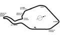 | 860 × 508 (14 KB) | Micap | en:North reference added it:Aggiunta indicazione del Nord |
| 23:55, 20 January 2010 | 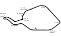 | 860 × 508 (13 KB) | Micap | {{Information |Description={{en|1=Circuit de Rouen-les-Essarts track layout from 1955 to 1971.}} {{it|1=Mappa del tracciato del Circuito di Rouen-les-Essarts dal 1955 al 1971}} |Source={{own}} |Author=Micap |Date=20-01-2010 |Permission= |ot |
File usage
The following pages on the English Wikipedia use this file (pages on other projects are not listed):
Global file usage
The following other wikis use this file:
- Usage on ar.wikipedia.org
- Usage on bg.wikipedia.org
- Usage on br.wikipedia.org
- Usage on cs.wikipedia.org
- Usage on da.wikipedia.org
- Usage on de.wikipedia.org
- Usage on es.wikipedia.org
- Usage on et.wikipedia.org
- Usage on fa.wikipedia.org
- Usage on fi.wikipedia.org
- Usage on fr.wikipedia.org
- Roger Pingeon
- Grand Prix automobile de France 1962
- Circuit de Rouen-les-Essarts
- Grand Prix automobile de France 1968
- Grand Prix automobile de France 1964
- Grand Prix automobile de France 1957
- Grand Prix moto de France 1965
- Grand Prix moto de France 1966
- Formule 1 en France
- Liste des circuits français de Formule 1
- Grand Prix automobile de Rouen-les-Essarts
View more global usage of this file.