
File:Robin Hood Gardens, Cotton Street - geograph.org.uk - 1517514.jpg

No higher resolution available.
Robin_Hood_Gardens,_Cotton_Street_-_geograph.org.uk_-_1517514.jpg (640 × 480 pixels, file size: 142 KB, MIME type: image/jpeg)
| This is a file from the Wikimedia Commons. Information from its description page there is shown below. Commons is a freely licensed media file repository. You can help. |
Summary
| Description |
English: Robin Hood Gardens, Cotton Street The west side of the west block. Robin Hood Gardens is one of London's most notorious 1960s housing estates which is loathed by some but revered by others as a beacon of modern architecture. There are probably more people in the former camp than the latter. There are two blocks aligned roughly north-south with a patch of green space between them. They were designed by Alison and Peter Smithson in 1966-72, with Christopher Woodward and Ken Baker of the Greater London Council. The buildings embody the Smithsons' idea of "streets in the sky" and are an example of concrete Brutalism, with the pre-cast concrete being rough and shuttered. Pevsner comments that while being "impressively monumental" the scheme is also "inhumane" because of the high density, the narrowness of the decks and its proximity to busy roads on two sides.
Tower Hamlets Council plan to demolish the buildings and redevelop the site. A campaign by the Twentieth Century Society and others to halt this by applying for listed building status in 2008 was unsuccessful. |
| Date | |
| Source | From geograph.org.uk |
| Author | Stephen Richards |
| Attribution (required by the license) | Stephen Richards / Robin Hood Gardens, Cotton Street (1) / |
| Camera location | | View this and other nearby images on: OpenStreetMap |
|---|
| Object location | | View this and other nearby images on: OpenStreetMap |
|---|
Licensing

|
This image was taken from the Geograph project collection. See this photograph's page on the Geograph website for the photographer's contact details. The copyright on this image is owned by Stephen Richards and is licensed for reuse under the Creative Commons Attribution-ShareAlike 2.0 license.
|
This file is licensed under the Creative Commons Attribution-Share Alike 2.0 Generic license.
Attribution: Stephen Richards
- You are free:
- to share – to copy, distribute and transmit the work
- to remix – to adapt the work
- Under the following conditions:
- attribution – You must give appropriate credit, provide a link to the license, and indicate if changes were made. You may do so in any reasonable manner, but not in any way that suggests the licensor endorses you or your use.
- share alike – If you remix, transform, or build upon the material, you must distribute your contributions under the same or compatible license as the original.
File history
Click on a date/time to view the file as it appeared at that time.
| Date/Time | Thumbnail | Dimensions | User | Comment | |
|---|---|---|---|---|---|
| current | 00:53, 3 March 2011 | 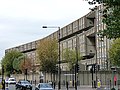 | 640 × 480 (142 KB) | GeographBot | == {{int:filedesc}} == {{Information |description={{en|1=Robin Hood Gardens, Cotton Street The west side of the west block. Robin Hood Gardens is one of London's most notorious 1960s housing estates which is loathed by some but revered by others as a beac |
File usage
The following pages on the English Wikipedia use this file (pages on other projects are not listed):
Global file usage
The following other wikis use this file:
- Usage on es.wikipedia.org
- Usage on it.wikipedia.org