
File:River Oughton at Oughtonhead Common - geograph.org.uk - 889594.jpg

River_Oughton_at_Oughtonhead_Common_-_geograph.org.uk_-_889594.jpg (640 × 480 pixels, file size: 343 KB, MIME type: image/jpeg)
| This is a file from the Wikimedia Commons. Information from its description page there is shown below. Commons is a freely licensed media file repository. You can help. |
Summary
| Description |
English: River Oughton at Oughtonhead Common From the Hertfordshire Countryside Magazine, April 1967:-
The Lucas family was closely associated with Oughton Head and owned much of the land around the common. William Lucas in his diary tells of his favourite walk out over Gaping Hills to Orton (sic) Head; Samuel Lucas drew and painted the countryside and birds; and Francis Lucas wrote poems which reflect the scene of fields and woods around and the men who worked them. They also helped shape the present aspects of Oughton Head as the following extracts from William Lucas's diary [A Quaker Diary, Published by Hutchinson & Co, 1933] show: 11th Month 7th, 1842: "Met the Leet Jury at Orton Head Common and they marked out a piece of ground to be given up to us in lieu of the cartway from the lane to our seven-acre piece. This piece I intend to plant" 12th Month 5th, 1842: "Finished planting my new clump at Orton Head. The ladies have all taken their share. J. Lister planted all the Poplars, Christiana Lucas all the Chestnuts, Sarah Lucas the Mountain Ash and Phebe Lucas the Abel Poplars." 12th Month 24th, 1843: "... and I have been planting Elms about Orton Head and Hungry Hill, also the small piece of land taken from the common, which should be called Ladies' Copse" |
| Date | |
| Source | From geograph.org.uk |
| Author | OLU |
| Camera location | | View this and other nearby images on: OpenStreetMap |
|---|
| Object location | | View this and other nearby images on: OpenStreetMap |
|---|
Licensing

|
This image was taken from the Geograph project collection. See this photograph's page on the Geograph website for the photographer's contact details. The copyright on this image is owned by OLU and is licensed for reuse under the Creative Commons Attribution-ShareAlike 2.0 license.
|
- You are free:
- to share – to copy, distribute and transmit the work
- to remix – to adapt the work
- Under the following conditions:
- attribution – You must give appropriate credit, provide a link to the license, and indicate if changes were made. You may do so in any reasonable manner, but not in any way that suggests the licensor endorses you or your use.
- share alike – If you remix, transform, or build upon the material, you must distribute your contributions under the same or compatible license as the original.
File history
Click on a date/time to view the file as it appeared at that time.
| Date/Time | Thumbnail | Dimensions | User | Comment | |
|---|---|---|---|---|---|
| current | 13:19, 21 February 2011 | 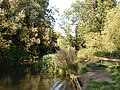 | 640 × 480 (343 KB) | GeographBot | == {{int:filedesc}} == {{Information |description={{en|1=River Oughton at Oughtonhead Common From the Hertfordshire Countryside Magazine, April 1967:- The Lucas family was closely associated with Oughton Head and owned much of the land around the commo |