
File:Ratusz, tablica (2014), 2020 Sárospatak.jpg

Size of this preview: 799 × 600 pixels. Other resolutions: 320 × 240 pixels | 640 × 480 pixels | 1,023 × 768 pixels | 1,280 × 961 pixels | 1,524 × 1,144 pixels.
Original file (1,524 × 1,144 pixels, file size: 397 KB, MIME type: image/jpeg)
| This is a file from the Wikimedia Commons. Information from its description page there is shown below. Commons is a freely licensed media file repository. You can help. |
Summary
| Description |
English: : Town Hall, Polish plaque (2014) on its facade- 32 Rákóczi Road and 2 Eötvös Road corner, Old Town, Sárospatak, Borsod-Abaúj-Zemplén County, Hungary.
Magyar: : Polgármesteri Hivatal, lengyel emléktábla (2014). 'Esze Tamás Általános Iskola' néven azonosító: -13747. - Borsod-Abaúj-Zemplén megye, Sárospatak, Óváros/Városközpont, Rákóczi út 32., Eötvös út sarok
Polski: : Ratusz, tablica (2014). - 32 Rakoczy drogowe, Sárospatak, Komitat Borsod-Abaúj-Zemplén, Węgry.
|
||||
| Date | |||||
| Source | Own work | ||||
| Author | Globetrotter19 |
| Object location | | View this and other nearby images on: OpenStreetMap |
|---|
| Camera location | | View this and other nearby images on: OpenStreetMap |
|---|
Licensing
I, the copyright holder of this work, hereby publish it under the following license:
This file is licensed under the Creative Commons Attribution-Share Alike 3.0 Unported license.
- You are free:
- to share – to copy, distribute and transmit the work
- to remix – to adapt the work
- Under the following conditions:
- attribution – You must give appropriate credit, provide a link to the license, and indicate if changes were made. You may do so in any reasonable manner, but not in any way that suggests the licensor endorses you or your use.
- share alike – If you remix, transform, or build upon the material, you must distribute your contributions under the same or compatible license as the original.
File history
Click on a date/time to view the file as it appeared at that time.
| Date/Time | Thumbnail | Dimensions | User | Comment | |
|---|---|---|---|---|---|
| current | 23:17, 22 December 2020 | 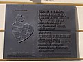 | 1,524 × 1,144 (397 KB) | Globetrotter19 | Uploaded own work with UploadWizard |
File usage
The following pages on the English Wikipedia use this file (pages on other projects are not listed):
Global file usage
The following other wikis use this file:
- Usage on hu.wikipedia.org